IMAGES TAKEN NEAR TO
Dovecote Close, OAKHAM, LE15 8ET
Introduction
This page details the photographs taken nearby to Dovecote Close, LE15 8ET by members of the Geograph project.
The Geograph project started in 2005 with the aim of publishing, organising and preserving representative images for every square kilometre of Great Britain, Ireland and the Isle of Man.

There are currently over 7.5m images from over14,400 individuals and you can help contribute to the project by visiting https://www.geograph.org.uk
Image Map (Loading...)


Getting Data...Please wait
Leaflet Map data © OpenStreetMap
Images are licensed for reuse under creativecommons.org/licenses/by-sa/2.0
Notes
- Clicking on the map will re-center to the selected point.
- The higher the marker number, the further away the image location is from the centre of the postcode.
Image Listing (118 Images Found)
Images are licensed for reuse under creativecommons.org/licenses/by-sa/2.0
Image
Details
Distance
1
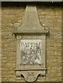
Datestone, former Baptist Chapel, Barrowden
See http://www.geograph.org.uk/photo/4908231 for location.
Image: © Alan Murray-Rust
Taken: 11 Apr 2016
0.05 miles
2
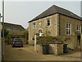
Former Baptist Chapel, Barrowden
Dated 1819 http://www.geograph.org.uk/photo/4908230, coursed stone rubble with ashlar dressings and Welsh slate hipped roof. Converted early 21st century to residential use, Listed Grade II.
Image: © Alan Murray-Rust
Taken: 11 Apr 2016
0.05 miles
3
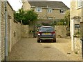
Forecourt to former Baptist Chapel, Barrowden
The cast iron gates visible beyond the car are Listed Grade II for group value. They were originally sited between the two stone piers in the foreground, but when the chapel was converted to a house, the gates were clearly too narrow to allow a car through, so they have been moved.
Image: © Alan Murray-Rust
Taken: 11 Apr 2016
0.05 miles
4
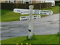
Fingerpost, Luffenham Road, Barrowden
Standard Rutland County Council concrete style, with extra arm added for the local shop.
Image: © Alan Murray-Rust
Taken: 4 Apr 2016
0.05 miles
5
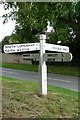
Old Direction Sign - Signpost Luffenham Road, Barrowden
Octagonal finial - 5 arms; Rutland County Council concrete by the UC road, in parish of Barrowden (Rutland District), junction of Wakerley Road with Luffenham Road, on grass triangle.
Surveyed
Milestone Society National ID: RU_SK9400C
Image: © Milestone Society
Taken: Unknown
0.06 miles
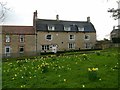
6
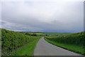
Luffenham Road leading down to Barrowden
The broad Welland Valley lies beyond the village.
Image: © Tim Heaton
Taken: 25 Apr 2018
0.06 miles
7
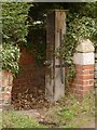
Cast iron pump, 1 Luffenham Road, Barrowden
In the yard behind the house.
Image: © Alan Murray-Rust
Taken: 4 Apr 2016
0.06 miles
8
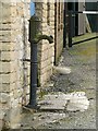
Barrowden village pump
Tucked into this alcove alongside Tippings Lane. Set sideways to the road, this makes the handle much easier to use.
Image: © Alan Murray-Rust
Taken: 4 Apr 2016
0.07 miles
9
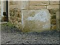
Bench mark, barn at 1 Luffenham Road, Barrowden
See http://www.geograph.org.uk/photo/4899886 for location.
Image: © Alan Murray-Rust
Taken: 4 Apr 2016
0.07 miles
10
3 Luffenham Road, Barrowden
House of around 1800, coursed stone rubble with Collyweston stone slate roof in unusual mansard style, Listed Grade II.
Image: © Alan Murray-Rust
Taken: 4 Apr 2016
0.07 miles