IMAGES TAKEN NEAR TO
Horseshoe Close, OAKHAM, LE15 7GL
Introduction
This page details the photographs taken nearby to Horseshoe Close, LE15 7GL by members of the Geograph project.
The Geograph project started in 2005 with the aim of publishing, organising and preserving representative images for every square kilometre of Great Britain, Ireland and the Isle of Man.

There are currently over 7.5m images from over14,400 individuals and you can help contribute to the project by visiting https://www.geograph.org.uk
Image Map (Loading...)


Getting Data...Please wait
Leaflet Map data © OpenStreetMap
Images are licensed for reuse under creativecommons.org/licenses/by-sa/2.0
Notes
- Clicking on the map will re-center to the selected point.
- The higher the marker number, the further away the image location is from the centre of the postcode.
Image Listing (33 Images Found)
Images are licensed for reuse under creativecommons.org/licenses/by-sa/2.0
Image
Details
Distance
1
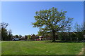
Solitary oak behind Grooms Close, Barleythorpe
Mature tree preserved in a green space area surrounded by extensive housing development.
Image: © Tim Heaton
Taken: 20 Apr 2020
0.04 miles
2
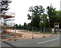
Martingale Mews
The site of the former Barleythorpe Stud is now a large building site.
Image: © Andrew Tatlow
Taken: 5 Sep 2010
0.04 miles
3
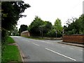
Main Road toward Oakham
Main Road passes the end of Manor Lane in Barleythorpe.
Image: © Andrew Tatlow
Taken: 5 Sep 2010
0.05 miles
4
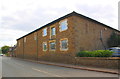
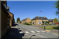
Building beside Main Road
There is an OS benchmark Image on the near corner of the building at the junction with a stone wall
Image: © Roger Templeman
Taken: 5 Apr 2016
0.07 miles
5
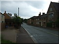
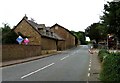
Main Road, Barleythorpe
The former A606. Now the B640, and much quieter, since the Oakham bypass was built in 2007.
Image: © Tim Heaton
Taken: 20 Apr 2020
0.08 miles
6
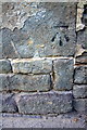
Benchmark on Main Road building
Ordnance Survey cut mark benchmark described on the Bench Mark Database at http://www.bench-marks.org.uk/bm70629
Image: © Roger Templeman
Taken: 5 Apr 2016
0.08 miles
8
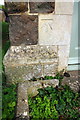
Benchmark on #11 Main Road
Ordnance Survey cut mark benchmark described on the Bench Mark Database at http://www.bench-marks.org.uk/bm74919
Image: © Roger Templeman
Taken: 5 Apr 2016
0.09 miles
9
Main Road towards Langham
The former Barleythorpe Stud was to the right.
Image: © Andrew Tatlow
Taken: 5 Sep 2010
0.10 miles
10
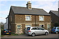
Nos. 11 and 9 Main Road
There is an OS benchmark Image on a stone in the left hand surround of the door of the left hand house
Image: © Roger Templeman
Taken: 5 Apr 2016
0.10 miles