IMAGES TAKEN NEAR TO
Cresswell Drive, OAKHAM, LE15 7DY
Introduction
This page details the photographs taken nearby to Cresswell Drive, LE15 7DY by members of the Geograph project.
The Geograph project started in 2005 with the aim of publishing, organising and preserving representative images for every square kilometre of Great Britain, Ireland and the Isle of Man.

There are currently over 7.5m images from over14,400 individuals and you can help contribute to the project by visiting https://www.geograph.org.uk
Image Map (Loading...)


Getting Data...Please wait
Leaflet Map data © OpenStreetMap
Images are licensed for reuse under creativecommons.org/licenses/by-sa/2.0
Notes
- Clicking on the map will re-center to the selected point.
- The higher the marker number, the further away the image location is from the centre of the postcode.
Image Listing (89 Images Found)
Images are licensed for reuse under creativecommons.org/licenses/by-sa/2.0
Image
Details
Distance
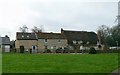
1
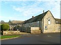
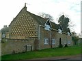
Former Cottesmore Hall outbuildings
The Hall itself was seriously damaged by fire in 1928 and the remains finally demolished in 1974. This range may include material from as early as about 1500 although what can be seen is probably 17th or 18th century. It was probably stabling, incorporating a cottage and is now completely converted to residential use. Listed Grade II.
Image: © Alan Murray-Rust
Taken: 19 Jan 2016
0.07 miles
2
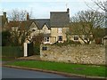
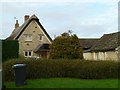
19, Mill Lane, Cottesmore (The Farrier's House)
A house which has clearly grown piecemeal over the years, dating from the 18th century (probably the tall central section). Listed Grade II.
Image: © Alan Murray-Rust
Taken: 19 Jan 2016
0.08 miles
3
Rear of Old Hall Mews, Mill Lane, Cottesmore
Grade II Listed former outbuildings of Cottesmore Hall probably cottage and stabling, of late 15th early 16th century and later now converted to dwellings. An enclosed horse exercise ring in the centre on what is now Old Hall Mews was demolished some years ago. The development comprises 11 dwellings and 4 garages. The rear of (right to left) 4,5,6 and 7 (gable end) are visible here. (Mill Lane was Formerly The Sheepdyke.)
Image: © Jo and Steve Turner
Taken: 24 Aug 2023
0.08 miles
4
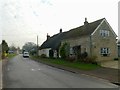
Lilac Farmhouse, Mill Lane
18th century farmhouse in coursed limestone rubble with thatched roof. The extension on this end is later. Listed Grade II.
Image: © Alan Murray-Rust
Taken: 28 Jan 2016
0.09 miles
5
The Tithe Barn
A large stone barn with origins in the 15th century, although much altered, it belonged to the church but never appears to have actually served as a tithe barn. Converted in 1974 incorporating material from the demolished Cottesmore Hall, it is now a Bed and Breakfast. The rows of external pigeonholes on the gable are a notable feature.
Image: © Alan Murray-Rust
Taken: 19 Jan 2016
0.09 miles
6
16, Mill Lane, Cottesmore
Stone-built thatched cottage, dated 1734. Listed Grade II.
Image: © Alan Murray-Rust
Taken: 19 Jan 2016
0.10 miles
7
18, 20, 22 Mill Lane
Nos. 18 and 20, the thatched portion of the range, date from the 18th century, with earlier origins, including a cruck frame. Listed Grade II. (No.22, nearest is later and much modernised.)
Image: © Alan Murray-Rust
Taken: 19 Jan 2016
0.11 miles
8
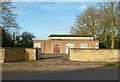
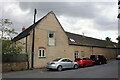
Cottesmore telephone exchange
Most exchanges are unassuming pieces of architecture which are nevertheless readily recognisable as what they are.
Image: © Alan Murray-Rust
Taken: 19 Jan 2016
0.12 miles
9
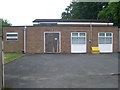
Cottesmore Telephone Exchange
Situated on the B668 Main Street near Mill Lane, this TE has the code EMCOTTE and would date from the early 1970s replacing a smaller building from the GPO era in the same locality. It now provides telephone and broadband services to 1,413 residential and 49 non-residential premises in Cottesmore, plus Ashwell, Exton and Greetham nearby. A yellow grit salt bin can be seen at the side of this TE. It has (01572) 812xxx, 813xxx numbers, the (01572) referring to the Oakham group of nine TEs, and its postcode is LE15 7DJ.
Image: © David Hillas
Taken: 25 Jun 2012
0.12 miles
10
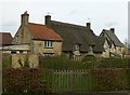
Honeypot Cottage and neighbours
Honeypot Cottage is the end to the right, No.73 being the thatched extension leftwards. They comprise a pair of 18th century cottages in coursed limestone rubble. Listed Grade II.
Image: © Alan Murray-Rust
Taken: 19 Jan 2016
0.13 miles