IMAGES TAKEN NEAR TO
West Road, OAKHAM, LE15 6BF
Introduction
This page details the photographs taken nearby to West Road, LE15 6BF by members of the Geograph project.
The Geograph project started in 2005 with the aim of publishing, organising and preserving representative images for every square kilometre of Great Britain, Ireland and the Isle of Man.

There are currently over 7.5m images from over14,400 individuals and you can help contribute to the project by visiting https://www.geograph.org.uk
Image Map
Images are licensed for reuse under creativecommons.org/licenses/by-sa/2.0
Notes
- Clicking on the map will re-center to the selected point.
- The higher the marker number, the further away the image location is from the centre of the postcode.
Image Listing (74 Images Found)
Images are licensed for reuse under creativecommons.org/licenses/by-sa/2.0
Image
Details
Distance
1
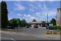
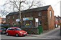
Local Co-op Food store, West Road, Oakham
"... there are over 4,000 co-operative food shops in the UK, more outlets than any other grocer." https://en.wikipedia.org/wiki/Co-op_Food
Image: © Tim Heaton
Taken: 6 Aug 2018
0.00 miles
5
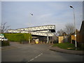
Footbridge from Braunston Road to South Street, Oakham
From the road layout, I assume there was once a level crossing here.
Image: © Richard Vince
Taken: 8 Mar 2014
0.15 miles
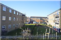
6
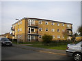
Low rise flats on Derwent Drive, Oakham
The northernmost of three similar blocks on Derwent Drive.
Image: © Richard Vince
Taken: 8 Mar 2014
0.15 miles
7
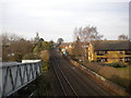
Railway line through Oakham
Looking north, towards Oakham station, Melton Mowbray, and Leicester, from the footbridge at the west end of South Street. In the distance, the footbridge at the level crossing immediately south of the station can be glimpsed; from the road layout, I assume there was once a level crossing here too.
Image: © Richard Vince
Taken: 8 Mar 2014
0.16 miles
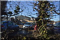
8
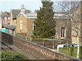
Chapel - St Anne's Close
This little chapel is in a housing complex and I couldn't see a way to on the ground, although the aerial view suggests a way round from the north. This is photographed from a footbridge over the railway line.
Image: © Chris Allen
Taken: 8 Mar 2014
0.16 miles
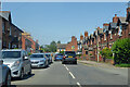
9
'Overton House', Cold Overton Road
There is an OS benchmark Image on the right hand side of the building, right of a green downpipe
Image: © Roger Templeman
Taken: 5 Apr 2016
0.16 miles
10
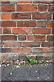
Benchmark on #42 Cold Overton Road
Ordnance Survey cut mark benchmark described on the Bench Mark Database at http://www.bench-marks.org.uk/bm74921
Image: © Roger Templeman
Taken: 5 Apr 2016
0.16 miles