IMAGES TAKEN NEAR TO
Cunnington Close, OAKHAM, LE15 6AD
Introduction
This page details the photographs taken nearby to Cunnington Close, LE15 6AD by members of the Geograph project.
The Geograph project started in 2005 with the aim of publishing, organising and preserving representative images for every square kilometre of Great Britain, Ireland and the Isle of Man.

There are currently over 7.5m images from over14,400 individuals and you can help contribute to the project by visiting https://www.geograph.org.uk
Image Map
Images are licensed for reuse under creativecommons.org/licenses/by-sa/2.0
Notes
- Clicking on the map will re-center to the selected point.
- The higher the marker number, the further away the image location is from the centre of the postcode.
Image Listing (531 Images Found)
Images are licensed for reuse under creativecommons.org/licenses/by-sa/2.0
Image
Details
Distance
1
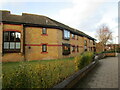
Sheltered housing, Oakham
William Dalby Walk.
Image: © Jonathan Thacker
Taken: 9 Jan 2023
0.02 miles
4
The road into the car park
We tried to pay in the car park but the machine's instructions were not clear and the the buttons seemed not to be working so we left within the 30 minute grace period.
Image: © Malcolm Neal
Taken: 9 Jun 2023
0.04 miles
5
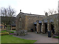
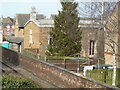
Chapel of St John and St Anne
The chapel of a charitable hospice founded in 1399 by William Dalby, it is a simple rectangular building in Perpendicular style. It now stands at the centre of a modern group of almshouses, built in the 1980s, at which time the chapel was also renovated. Listed Grade II*.
Image: © Alan Murray-Rust
Taken: 8 Mar 2014
0.04 miles
6
Chapel of the Hospitallers of St John the Evangelist and St Anne
Dates from the fifteenth century https://historicengland.org.uk/listing/the-list/list-entry/1073262?section=official-list-entry
Image: © Jonathan Thacker
Taken: 9 Jan 2023
0.04 miles
7
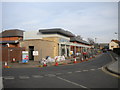
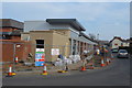
New bus interchange under construction, Oakham
A small bus station being constructed on John Street, in place of the previous set of bus stops that performed the same function. Originally, Rutland Council had intended to construct the interchange outside the railway station, but public consultation unsurprisingly revealed that the vast majority of bus passenger journeys to Oakham are made to get to Oakham itself rather than to get to the railway station to catch a train to somewhere else. The station is not far away, but putting the interchange here means the walk has to be undertaken by far fewer people.
Image: © Richard Vince
Taken: 8 Mar 2014
0.04 miles
8
13 Westgate, Oakham, Rutland - 1960's
This is an old photo that my father took from the disused factory that was on the corner of Westgate/High street Oakham. Our house is the one with the white van outside - no 13 Westgate, Oakham. It was knocked down about 3 years ago. The shop is no longer there, that was knocked down along with most of the area in the 1980's.
Image: © Wendy Sanders
Taken: 1 Feb 1965
0.05 miles
9
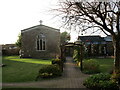
Chapel - St Anne's Close
This little chapel is in a housing complex and I couldn't see a way to on the ground, although the aerial view suggests a way round from the north. This is photographed from a footbridge over the railway line.
Image: © Chris Allen
Taken: 8 Mar 2014
0.05 miles
10
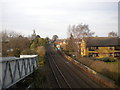
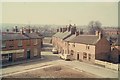
Railway line through Oakham
Looking north, towards Oakham station, Melton Mowbray, and Leicester, from the footbridge at the west end of South Street. In the distance, the footbridge at the level crossing immediately south of the station can be glimpsed; from the road layout, I assume there was once a level crossing here too.
Image: © Richard Vince
Taken: 8 Mar 2014
0.05 miles