IMAGES TAKEN NEAR TO
LE15 0HA
Introduction
This page details the photographs taken nearby to LE15 0HA by members of the Geograph project.
The Geograph project started in 2005 with the aim of publishing, organising and preserving representative images for every square kilometre of Great Britain, Ireland and the Isle of Man.

There are currently over 7.5m images from over14,400 individuals and you can help contribute to the project by visiting https://www.geograph.org.uk
Image Map (Loading...)


Getting Data...Please wait
Leaflet Map data © OpenStreetMap
Images are licensed for reuse under creativecommons.org/licenses/by-sa/2.0
Notes
- Clicking on the map will re-center to the selected point.
- The higher the marker number, the further away the image location is from the centre of the postcode.
Image Listing (589 Images Found)
Images are licensed for reuse under creativecommons.org/licenses/by-sa/2.0
Image
Details
Distance
1
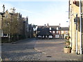
The Market Place, Oakham
This is taken from corner of the small cobbled street that leads to the site of Oakham Castle and the still existing Great Hall. The entrance to the Oakham boarding school can be seen in the distance, in the left corner of the market square. The large covered area in the centre of the square is the Oakham Buttercross. Note the absence of people as it is Sunday morning (not a Saturday market day!) as well as the cloud formations and vapour trails in the blue sky.
Image: © Paul Whittington
Taken: 13 Jan 2007
0.01 miles
2
Post Office and Savings Bank, Oakham
In Oakham Market Place.
Image: © Andrew Abbott
Taken: 26 Aug 2013
0.01 miles
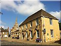
3
Oakham, Rutland (Market Place)
The late 15th century grade I-listed butter cross (a former dairy-produce sales point, with a roof in this case) also houses a set of lower-limb stocks and a former source of the town's water supply - the pump. The gated entrance to the very well-known Oakham independent school - founded in 1585 - is located adjacent to the very substantial wooden door on the right.
Image: © David Hallam-Jones
Taken: 23 Jun 2012
0.01 miles
4
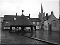
Marketplace, Oakham, 2001
In the foreground is the pump, also shown at http://www.geograph.org.uk/search.php?i=78100062 and described at https://historicengland.org.uk/listing/the-list/list-entry/1361782 . This description seems to have become confused between the pump and the butter cross, since this roof is clearly not octagonal. Across the market place is the post office on the right, and, on the left, the north end of the buildings described at https://www.historicengland.org.uk/listing/the-list/list-entry/1177830 . The market place is crossed by the Rutland Round and the Viking Way.
Image: © Derek Harper
Taken: 22 Oct 2001
0.01 miles
5
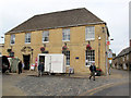
Oakham Post Office
The building still bears the legend "Post Office Savings Bank". That became Girobank and eventually part of Santander.
Image: © Stephen Craven
Taken: 9 Aug 2011
0.01 miles
6
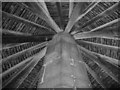
Under the roof of the Butter Cross
Whilst sheltering from the icy rain one gets an opportunity to admire the construction of this seventeenth century building.
Image: © Alison Rawson
Taken: 23 Nov 2008
0.01 miles
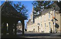
7
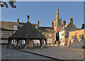
Oakham Market Place
With the Buttercross to the left and the spire of All Saints Church to the right
Image: © Paul Harrop
Taken: 15 Oct 2023
0.01 miles
8
The Butter Cross
A seventeenth century building, fantastic to shelter under on a day like this!
Image: © Alison Rawson
Taken: 23 Nov 2008
0.01 miles
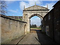
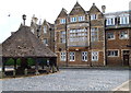
10
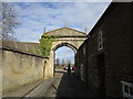
Gateway to Oakham Castle
Of uncertain date, the Buildings of England suggests thirteenth century with alterations and additions in the seventeenth and nineteenth centuries. The listing suggests it is the work of the Second Duke of Buckingham which would date it to c1700.
Image: © Jonathan Thacker
Taken: 21 Feb 2019
0.01 miles