IMAGES TAKEN NEAR TO
Church Gate, LEICESTER, LE1 4AF
Introduction
This page details the photographs taken nearby to Church Gate, LE1 4AF by members of the Geograph project.
The Geograph project started in 2005 with the aim of publishing, organising and preserving representative images for every square kilometre of Great Britain, Ireland and the Isle of Man.

There are currently over 7.5m images from over14,400 individuals and you can help contribute to the project by visiting https://www.geograph.org.uk
Image Map
Images are licensed for reuse under creativecommons.org/licenses/by-sa/2.0
Notes
- Clicking on the map will re-center to the selected point.
- The higher the marker number, the further away the image location is from the centre of the postcode.
Image Listing (579 Images Found)
Images are licensed for reuse under creativecommons.org/licenses/by-sa/2.0
Image
Details
Distance
1
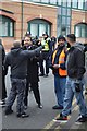
Confrontation in Leicester
Lib Dem MP tries to calm down a man who is angry with the EDL a few metres away.
Image: © Ashley Dace
Taken: 4 Feb 2012
0.01 miles
2
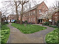
Leicester - City Centre
Two footpaths on one side of "The Great Meeting Chapel", a Unitarian place of worship on East Bond Street. The chapel - for "Protestant dissentors" - was built in 1708 on the site of an orchard. It is described as "the earliest complete brick building in Leicester" and while in the past it provided a worship base for many of Leicester's leading hosiery manufacturers, today it apparently strives to meet the needs of contemporary worshippers and the local community.
Image: © David Hallam-Jones
Taken: 1 Apr 2012
0.04 miles
3
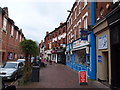
Leicester - City Centre
An occasional meeting place perhaps, courtesy of the public bench in this quiet shopping street? The street name signs above two of the shops show that this is where two streets meet. The sign above the Catholic repository shop (painted in luminous blue) shows this end of the street to be New Bond St whilst the street name sign over "Skin City" (a beauty salon) shows it to be in East Bond Street.
Image: © David Hallam-Jones
Taken: 31 Mar 2012
0.04 miles
4

Benchmark on #66 Church Gate
Ordnance Survey cut mark benchmark described on the Bench Mark Database at https://www.bench-marks.org.uk/bm69147
Image: © Roger Templeman
Taken: 8 May 2017
0.05 miles
5

Furniture warehouse, #66 Church Gate
There is an OS benchmark Image on a black quoin near the right hand edge of the image
Image: © Roger Templeman
Taken: 8 May 2017
0.05 miles
6

The Cherry Tree public house
On the corner of East Bond Street and St Peters Lane.
Image: © Mat Fascione
Taken: 2 Jul 2016
0.05 miles
7
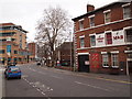
Leicester - City Centre
A view along East Bond Street. Beyond the "Cherry Tree" pub the fence, gates and part of "The Great Meeting Chapel" (a Unitarian Church) can be seen. This area was apparently an orchard in the 1700s.
Image: © David Hallam-Jones
Taken: 31 Mar 2012
0.05 miles
8
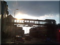
Debenham's Bridge, Shires Centre, Leicester
This picture was taken only days before this bridge was demolished as part of the expansion of the Shires Centre. The buildings on the right were also demolished about the same time.
Image: © Tim Hallam
Taken: 3 Mar 2006
0.06 miles
9
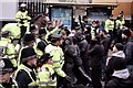
Police Clash
To the left, out of view the EDL are marching and chanting with Leicester's locals not liking it!
Image: © Ashley Dace
Taken: 4 Feb 2012
0.06 miles
10
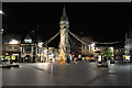
Leicester clock tower at night
The central clock tower in the shopping area of the city. Shops include McDonald's, Pizza hut, Greggs and a few clothing shops (from memory).
Image: © Ashley Dace
Taken: 24 Oct 2010
0.06 miles