IMAGES TAKEN NEAR TO
Saxby Road, MELTON MOWBRAY, LE14 4RZ
Introduction
This page details the photographs taken nearby to Saxby Road, LE14 4RZ by members of the Geograph project.
The Geograph project started in 2005 with the aim of publishing, organising and preserving representative images for every square kilometre of Great Britain, Ireland and the Isle of Man.

There are currently over 7.5m images from over14,400 individuals and you can help contribute to the project by visiting https://www.geograph.org.uk
Image Map
Images are licensed for reuse under creativecommons.org/licenses/by-sa/2.0
Notes
- Clicking on the map will re-center to the selected point.
- The higher the marker number, the further away the image location is from the centre of the postcode.
Image Listing (7 Images Found)
Images are licensed for reuse under creativecommons.org/licenses/by-sa/2.0
Image
Details
Distance
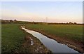
2
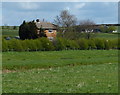
Farmland near Thorpe Arnold, Leicestershire
Shipman's Barn Stud on the skyline, Brentingby Lodge in the distance
Image: © Kate Jewell
Taken: 16 Nov 2005
0.13 miles
6
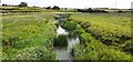
Looking east along River Eye from Lag Lane bridge
Image: © Roger Templeman
Taken: 27 May 2022
0.24 miles