IMAGES TAKEN NEAR TO
Lag Lane, MELTON MOWBRAY, LE14 4RU
Introduction
This page details the photographs taken nearby to Lag Lane, LE14 4RU by members of the Geograph project.
The Geograph project started in 2005 with the aim of publishing, organising and preserving representative images for every square kilometre of Great Britain, Ireland and the Isle of Man.

There are currently over 7.5m images from over14,400 individuals and you can help contribute to the project by visiting https://www.geograph.org.uk
Image Map
Images are licensed for reuse under creativecommons.org/licenses/by-sa/2.0
Notes
- Clicking on the map will re-center to the selected point.
- The higher the marker number, the further away the image location is from the centre of the postcode.
Image Listing (25 Images Found)
Images are licensed for reuse under creativecommons.org/licenses/by-sa/2.0
Image
Details
Distance
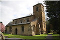
1
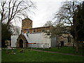
New roofs being installed at St. Mary's church, Thorpe Arnold
The lead roofs of both the north and south aisles were stolen in February 2019 https://www.meltontimes.co.uk/news/raiders-steal-roof-lead-from-three-melton-area-churches-1-8806801
Image: © Jonathan Thacker
Taken: 3 Feb 2020
0.04 miles
2
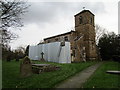
St. Mary's church, Thorpe Arnold
The lead roofs of both the north and south aisles were stolen in February 2019 and are now being replaced.
Image: © Jonathan Thacker
Taken: 3 Feb 2020
0.04 miles
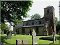
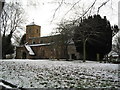
3
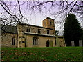
Church of St. Mary the Virgin, Thorpe Arnold
Serves the Anglican ecclesiastical needs of the Thorpe Arnold residents - a village on the eastern outskirts of Melton Mowbray
Image: © Chris Heaton
Taken: 13 Dec 2013
0.05 miles
4
St Mary the Virgin, Thorpe Arnold
Small ironstone church on the busy A607 just outside Melton Mowbray.
Image: © Kate Jewell
Taken: 16 Nov 2005
0.05 miles
5
St Mary's Church
There is an OS benchmark Image on the near corner, shaded face, of the tower
Image: © Roger Templeman
Taken: 18 Apr 2014
0.05 miles
6
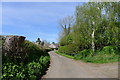
Lag Lane approaching Thorpe Arnold
'Thorpe' from old Norse 'torp', a secondary settlement, outlying farmstead http://kepn.nottingham.ac.uk/map/place/Leicestershire/Thorpe%20Arnold, 'Arnold' from Arnold de Bois, its first Norman owner (Wikipedia)
Image: © Tim Heaton
Taken: 15 Apr 2020
0.05 miles
7
The Church of St Mary The Virgin, Thorpe Arnold
Image: © Bill Henderson
Taken: 25 Jul 2012
0.05 miles
9
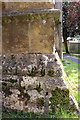
Benchmark on St Mary's Church
Ordnance Survey cut mark benchmark described on the Bench Mark Database at http://www.bench-marks.org.uk/bm57026
Image: © Roger Templeman
Taken: 18 Apr 2014
0.05 miles
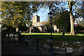
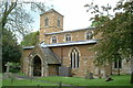
10
Church of St Mary the Virgin, Thorpe Arnold
Dating back to the mid 12th century, with rebuilding in the 19th. Has an active programme of services shared with St James (Burton Lazars) and St Mary's (Melton Mowbray)
Image: © Tim Heaton
Taken: 27 Dec 2005
0.05 miles