IMAGES TAKEN NEAR TO
Stow Hill, MELTON MOWBRAY, LE14 4QZ
Introduction
This page details the photographs taken nearby to Stow Hill, LE14 4QZ by members of the Geograph project.
The Geograph project started in 2005 with the aim of publishing, organising and preserving representative images for every square kilometre of Great Britain, Ireland and the Isle of Man.

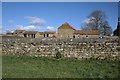
There are currently over 7.5m images from over14,400 individuals and you can help contribute to the project by visiting https://www.geograph.org.uk
Image Map
Images are licensed for reuse under creativecommons.org/licenses/by-sa/2.0
Notes
- Clicking on the map will re-center to the selected point.
- The higher the marker number, the further away the image location is from the centre of the postcode.
Image Listing (76 Images Found)
Images are licensed for reuse under creativecommons.org/licenses/by-sa/2.0
Image
Details
Distance
1
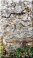
Benchmark on #3 Church Lane
Ordnance Survey cut mark benchmark levelled at 146.143m above Newlyn Datum verified 1970
Image: © Roger Templeman
Taken: 28 Jun 2023
0.03 miles
2
#3 Church Lane
There is an Ordnance Survey benchmark Image on the near corner, right hand face, of the house
Image: © Roger Templeman
Taken: 28 Jun 2023
0.04 miles
3
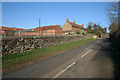
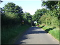
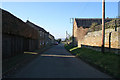
Stow Hill, Sproxton
This road leads to Skillington.
Sproxton is pronounced "Sproson" and is one of a group of villages with similar spelling and pronunciation.
Image: © Kate Jewell
Taken: 17 Feb 2008
0.04 miles
4
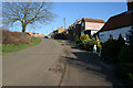
Looking up School Hill, Sproxton
This was the edge of the village and the majority of the cottages and houses on the south east side of the road are 19th century or older. At the upper end of School Hill they have an uninterrupted view of the church which sits on the hill that dominates the village to the north, see Image
Image: © Kate Jewell
Taken: 17 Feb 2008
0.04 miles
5
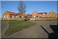
Hill Crest Farm, Sproxton
On Church Lane and appropriately named at the top of School Hill.
Image: © Kate Jewell
Taken: 17 Feb 2008
0.05 miles
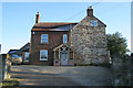
6
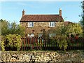
Hillcrest Farmhouse, Church Lane, Sproxton
Early 19th century farmhouse, coursed ironstone with Pantiled Roof, Listed Grade II.
Image: © Alan Murray-Rust
Taken: 13 Nov 2016
0.05 miles
7
Church Lane, Sproxton
The road bends to the right at climbs up the hill to the church which is out of sight behind the building on the right.
Note the orange ironstone used for building and the dark glazed tiles. These are Bottesford Blues, (although they're black!), and are clay pantiles finished with a hard wearing glaze. Locally made in Bottesford, Image and Image, in the 18th and 19th centuries these are a common sight in the north east Leicestershire villages. The secret glaze "recipe" was lost when the tile works closed but it is rumoured that the secret has been discovered and they will be made again. In the mean time the only supply of anything similar, if wanted for renovation work, is from Holland.
Image: © Kate Jewell
Taken: 17 Feb 2008
0.06 miles
8
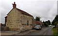
The Old Vicarage, Sproxton
On the junction of Church Lane and Stow Hill. If you look at the map you'll see that the church is quite a way out of the village, see Image, so the vicar would have had a pleasant walk every Sunday.
Image: © Kate Jewell
Taken: 17 Feb 2008
0.06 miles