IMAGES TAKEN NEAR TO
Coal Lane, MELTON MOWBRAY, LE14 4JL
Introduction
This page details the photographs taken nearby to Coal Lane, LE14 4JL by members of the Geograph project.
The Geograph project started in 2005 with the aim of publishing, organising and preserving representative images for every square kilometre of Great Britain, Ireland and the Isle of Man.

There are currently over 7.5m images from over14,400 individuals and you can help contribute to the project by visiting https://www.geograph.org.uk
Image Map
Images are licensed for reuse under creativecommons.org/licenses/by-sa/2.0
Notes
- Clicking on the map will re-center to the selected point.
- The higher the marker number, the further away the image location is from the centre of the postcode.
Image Listing (24 Images Found)
Images are licensed for reuse under creativecommons.org/licenses/by-sa/2.0
Image
Details
Distance
1
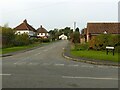
Coal Lane, Harby
There are no available clues to the origin of the name. There was certainly no coal extraction locally!
Image: © Alan Murray-Rust
Taken: 19 Oct 2020
0.02 miles
2
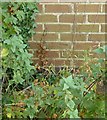
Bench mark, bus shelter at Coal Lane, Hose
See http://www.geograph.org.uk/photo/5178775 for location.
Image: © Alan Murray-Rust
Taken: 31 Oct 2016
0.03 miles
3
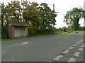
Bus shelter opposite Coal Lane, Hose
The village currently still has a regular service running between either Bingham or Bottesford and Melton Mowbray.
There is a bench mark http://www.geograph.org.uk/photo/5178772 on the near end of the shelter.
Image: © Alan Murray-Rust
Taken: 31 Oct 2016
0.03 miles
4
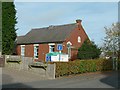
Hose Baptist Church
The stone in the gable reads 'Erected 1818, enlarged 1841, restored 1903'. I suspect that the 1903 restoration was effectively a rebuild.
Image: © Alan Murray-Rust
Taken: 31 Oct 2016
0.06 miles
5
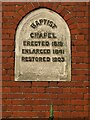
Hose Baptist Church, datestone
See http://www.geograph.org.uk/photo/6644901 for location.
Image: © Alan Murray-Rust
Taken: 19 Oct 2020
0.06 miles
6
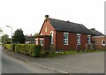
Hose Baptist Church
Early 20th century rebuilding of an earlier chapel http://www.geograph.org.uk/photo/6644911
Image: © Alan Murray-Rust
Taken: 19 Oct 2020
0.06 miles
7
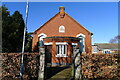
Baptist Chapel, Hose
Erected 1818, restored 1903.
Image: © Tim Heaton
Taken: 27 Feb 2021
0.06 miles
8
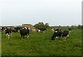
Grazing cattle near The Grange, Hose - and how to influence the weather
Those who believe the adage that the cows' posture predicts rain or not should be aware that before I crossed their field, they were all lying down, but inevitably stood up as I crossed the field through the herd. So how will the rain behave?!
Image: © Alan Murray-Rust
Taken: 19 Oct 2020
0.09 miles
9
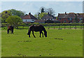
Horses near the village of Hose
The houses are along Harby Lane.
Image: © Mat Fascione
Taken: 14 Apr 2014
0.09 miles
10
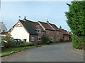
Cottages on Willow Lane
The furthest part, with skylights, dates from the 18th century and is Listed Grade II.
Image: © Alan Murray-Rust
Taken: 31 Oct 2016
0.10 miles