IMAGES TAKEN NEAR TO
Main Street, MELTON MOWBRAY, LE14 4EH
Introduction
This page details the photographs taken nearby to Main Street, LE14 4EH by members of the Geograph project.
The Geograph project started in 2005 with the aim of publishing, organising and preserving representative images for every square kilometre of Great Britain, Ireland and the Isle of Man.

There are currently over 7.5m images from over14,400 individuals and you can help contribute to the project by visiting https://www.geograph.org.uk
Image Map
Images are licensed for reuse under creativecommons.org/licenses/by-sa/2.0
Notes
- Clicking on the map will re-center to the selected point.
- The higher the marker number, the further away the image location is from the centre of the postcode.
Image Listing (79 Images Found)
Images are licensed for reuse under creativecommons.org/licenses/by-sa/2.0
Image
Details
Distance
1
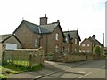
The Cottage, Main Street, Eastwell
A pair of 19th century cottages, almost certainly built by the Belvoir Estate.
Image: © Alan Murray-Rust
Taken: 31 Oct 2016
0.01 miles
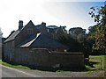
2
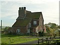
The Manor House, Eastwell
Originally a farmhouse, although all trace of the farm has disappeared.
Built in the late 17th century, it was originally T-shaped with central chimney stack, the northern wing being replaced in the 18th century with the sloping roofed extension visible here. There are original stone-mullioned windows visible in the right hand gable. Listed Grade II.
Image: © Alan Murray-Rust
Taken: 31 Oct 2016
0.05 miles
3
26 and 28, Main Street, Eastwell
A pair of late 18th century houses in local ironstone with pantiled roof, Listed Grade II.
Image: © Alan Murray-Rust
Taken: 31 Oct 2016
0.05 miles
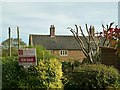
4
Former smithy, Eastwell
Now a private garage, but the former function is immediately evident from the style of the building.
Image: © Alan Murray-Rust
Taken: 31 Oct 2016
0.08 miles
5
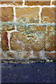
Benchmark on barn, Hall Lane
Ordnance Survey cut mark benchmark described on the Bench Mark Database at http://www.bench-marks.org.uk/bm47903
Image: © Roger Templeman
Taken: 2 Apr 2013
0.09 miles
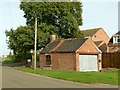
6
Barn on Hall Lane at Scalford Road junction
There is an OS benchmark Image on the second stone course above the pavement at the middle of this face
Image: © Roger Templeman
Taken: 2 Apr 2013
0.09 miles
7
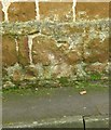
Bench mark, Eyresgarth, Eastwell
Much eroded, the local ironstone being very soft. See http://www.geograph.org.uk/photo/5179002 for location.
Image: © Alan Murray-Rust
Taken: 31 Oct 2016
0.09 miles
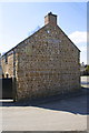
8

The village of Eastwell in Leicestershire
Image: © Mat Fascione
Taken: 5 Jun 2010
0.09 miles
9
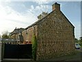
Eyresgarth, Eastwell
Originally a barn, built as an extension to the stable block.
There is a bench mark http://www.geograph.org.uk/photo/5179003 in the centre of the gable end.
Image: © Alan Murray-Rust
Taken: 31 Oct 2016
0.09 miles
10
Eastwell Hall
“Façade of three wide bays with two big shaped gables. The windows sashed, the doorway also of the C18” (Nikolaus Pevsner). Eastwell Hall was built c. 1630 by a recusant Catholic family, the Eyres of Hassop in Derbyshire. It became part of the Belvoir Estate from 1792 until 1921. As late as 1780 Eastwell had the largest Catholic population in the county, apart from Leicester, and a Catholic Chapel was built nearby in 1798, replacing one at the Hall closed by the Duke of Rutland. The house is largely hidden from the road and the picture was taken against strong morning sunlight during the heat wave at the end of September 2011.
Image: © John Sutton
Taken: 30 Sep 2011
0.10 miles