IMAGES TAKEN NEAR TO
Seabrook Avenue, MELTON MOWBRAY, LE14 4BF
Introduction
This page details the photographs taken nearby to Seabrook Avenue, LE14 4BF by members of the Geograph project.
The Geograph project started in 2005 with the aim of publishing, organising and preserving representative images for every square kilometre of Great Britain, Ireland and the Isle of Man.

There are currently over 7.5m images from over14,400 individuals and you can help contribute to the project by visiting https://www.geograph.org.uk
Image Map
Images are licensed for reuse under creativecommons.org/licenses/by-sa/2.0
Notes
- Clicking on the map will re-center to the selected point.
- The higher the marker number, the further away the image location is from the centre of the postcode.
Image Listing (29 Images Found)
Images are licensed for reuse under creativecommons.org/licenses/by-sa/2.0
Image
Details
Distance
1
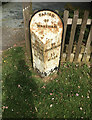
Old Milestone by the A607, Waltham
The milestone is on the grass verge on the southeast side of the road, in parish of Waltham (Melton District), erected in the 19th century.
Inscription reads:- TO / MELTON / MOBRAY / 5 / MILES :: PARISH / OF / WALTHAM :: TO / GRANTHAM / 11 / MILES
Milestone Society National ID: LE_MMGR05
Image: © william varnham
Taken: 11 May 2024
0.07 miles
2
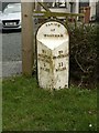
Milepost, Waltham on the Wolds
Cast iron milepost, 19th century, Melton Mowbray and Grantham Turnpike. Listed Grade II, Milestone Society ID LE_MMGR05
Image: © Alan Murray-Rust
Taken: 3 Mar 2020
0.08 miles
3
Waltham on the Wolds: A607 Melton Road
Image: © Mat Fascione
Taken: 15 May 2010
0.08 miles
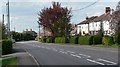
4

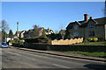
Melton Road, Waltham on the Wolds
The busy A607 to Grantham cuts through Waltham. There have been recent traffic calming measures made including pedestrian islands and a reduced width carriageway on the approach to the village. There is also a 20 miles per hour speed limit outside the school. Unfortunately none of these measures seem to have much effect on drivers.
Photograph taken looking north from the corner of Moor Leys Lane.
Image: © Kate Jewell
Taken: 17 Feb 2008
0.09 miles
5
Entering Waltham on the Wolds
Ona footpath from Chadwell.
Image: © Jonathan Thacker
Taken: 2 Apr 2021
0.09 miles
6

A607 Melton Road on the outskirts of Waltham on the Wolds
Note the milepost http://www.geograph.org.uk/photo/6411311 on the left hand side.
Image: © Alan Murray-Rust
Taken: 3 Mar 2020
0.09 miles
7
Cottages on Melton Road
These two sets of semi-detached cottages are constructed of limestone. All four have undergone extensive expansion over the years but still present a traditional façade to the road. Unfortunately only one retains the original lozenge design windows, see Image
Image: © Kate Jewell
Taken: 17 Feb 2008
0.10 miles
8
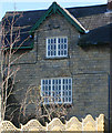
Detail of cottage on Melton Road, Waltham on the Wolds
This cottage, one of four semi-detached cottages on Melton Road, still retains its original windows. See Image
Image: © Kate Jewell
Taken: 17 Feb 2008
0.10 miles
9
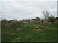
Gates and dilapidated stone wall, Waltham on the Wolds
On the edge of the village.
Image: © Jonathan Thacker
Taken: 2 Apr 2021
0.10 miles
10
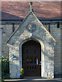
The school porch
This is the main visitor entrance to the school, the children access the buildings from the playground round the back. Note the coat of arms above the door which commemorates the erection of this building in 1844. It was built to replaced the old school which was founded by George Noble in 1776.
Image: © Kate Jewell
Taken: 17 Feb 2008
0.11 miles