IMAGES TAKEN NEAR TO
New Road, MELTON MOWBRAY, LE14 2UU
Introduction
This page details the photographs taken nearby to New Road, LE14 2UU by members of the Geograph project.
The Geograph project started in 2005 with the aim of publishing, organising and preserving representative images for every square kilometre of Great Britain, Ireland and the Isle of Man.

There are currently over 7.5m images from over14,400 individuals and you can help contribute to the project by visiting https://www.geograph.org.uk
Image Map
Images are licensed for reuse under creativecommons.org/licenses/by-sa/2.0
Notes
- Clicking on the map will re-center to the selected point.
- The higher the marker number, the further away the image location is from the centre of the postcode.
Image Listing (68 Images Found)
Images are licensed for reuse under creativecommons.org/licenses/by-sa/2.0
Image
Details
Distance
1
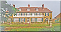
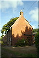
The Grange, Burton Lazars 1995
The south elevation of this fine Guesthouse on New Road.
Image: © Ben Brooksbank
Taken: 3 May 1995
0.00 miles
2
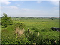
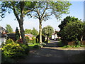
The bottom of Racecourse Lane
The square SK7716 lies before you. The photograph shows the site of an old horse racing course that was in use in the 1930s.
Image: © Paul Whittington
Taken: 2 Jun 2006
0.03 miles
3
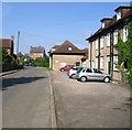
The Grange Country House Hotel
This is taken on New Road and shows the front of the Grange Country House Hotel.
Image: © Paul Whittington
Taken: 2 Jun 2006
0.03 miles
4
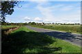
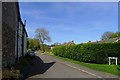
Towards Burton Lazars
This is the A606 towards Melton Mowbray. The village on the hillside is Burton Lazars.
Image: © Andrew Tatlow
Taken: 24 Oct 2010
0.06 miles
5
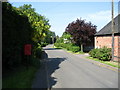
New Road
This is taken on New Road, looking east towards The Grange Country House Hotel that is around the following corner. New Road is one of the eight lanes that make up the small village of Burton Lazars.
Image: © Paul Whittington
Taken: 2 Jun 2006
0.06 miles
7
Peppers Lane, Burton Lazars
Spelt Pepper's Lane (with apostrophe) at the top of the lane. Takes the Jubilee Way through Burton Lazars towards Melton Mowbray.
Image: © Tim Heaton
Taken: 15 Apr 2020
0.08 miles
8
Bench mark, Lynne Cottage, Burton Lazars
See http://www.geograph.org.uk/photo/5274676 for location.
Image: © Alan Murray-Rust
Taken: 3 Feb 2017
0.08 miles
9
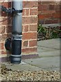
Lynne Cottage, #39 New Road
There is an OS benchmark Image on the near face of the house at its right hand corner, right of a downpipe
Image: © Roger Templeman
Taken: 4 Oct 2016
0.08 miles
10
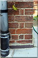
Benchmark on Lynne Cottage
Ordnance Survey cut mark benchmark described on the Bench Mark Database at http://www.bench-marks.org.uk/bm80113
Image: © Roger Templeman
Taken: 4 Oct 2016
0.08 miles