IMAGES TAKEN NEAR TO
Main Street, MELTON MOWBRAY, LE14 2EU
Introduction
This page details the photographs taken nearby to Main Street, LE14 2EU by members of the Geograph project.
The Geograph project started in 2005 with the aim of publishing, organising and preserving representative images for every square kilometre of Great Britain, Ireland and the Isle of Man.

There are currently over 7.5m images from over14,400 individuals and you can help contribute to the project by visiting https://www.geograph.org.uk
Image Map
Images are licensed for reuse under creativecommons.org/licenses/by-sa/2.0
Notes
- Clicking on the map will re-center to the selected point.
- The higher the marker number, the further away the image location is from the centre of the postcode.
Image Listing (58 Images Found)
Images are licensed for reuse under creativecommons.org/licenses/by-sa/2.0
Image
Details
Distance
1
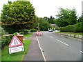
Traffic Lights
It is the roadworks season on the Melton Mowbray area with multiple and conflicting diversions in effect.
Image: © Andrew Tatlow
Taken: 13 Aug 2010
0.02 miles
2
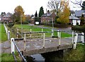
Bridge over brook at Great Dalby
This bridge over the brook in Great Dalby has a sign saying "DANGER BRIDGE UNSAFE" but it felt solid enough!
Image: © Andrew Tatlow
Taken: 3 Nov 2010
0.04 miles
3
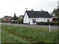
Cottage at Nether End
One of the older buildings, although not listed. It has clearly been thatched originally, but now sports the common corrugated iron replacement.
Image: © Alan Murray-Rust
Taken: 4 Aug 2011
0.04 miles
4
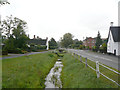
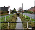
Nether End
The low part of the village, as the name implies, with a stream running alongside the main road to Melton Mowbray (B 6047). The white gabled cottage to the left is The White House, dating from the mid 18th century and Listed Grade II. At the time of the listing in 1988 it is described as an agricultural store, but it looks as if it may have returned to residential use.
Image: © Alan Murray-Rust
Taken: 4 Aug 2011
0.06 miles
6
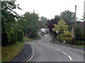
Up the hill, Great Dalby
Main Street climbs the hill from Nether End to Upper End.
Image: © Alan Murray-Rust
Taken: 4 Aug 2011
0.06 miles
9
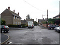
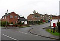
Burdetts Close
A small local authority development in the angle between Nether End and Main Street. The solitary system built house on the left is unusual in that generally the whole development would be uniform.
Image: © Alan Murray-Rust
Taken: 4 Aug 2011
0.07 miles
10
Brook through Great Dalby
This brook runs alongside Nether End in Great Dalby.
Image: © Andrew Tatlow
Taken: 3 Nov 2010
0.08 miles