IMAGES TAKEN NEAR TO
St. Margarets Street, LEICESTER, LE1 3EB
Introduction
This page details the photographs taken nearby to St. Margarets Street, LE1 3EB by members of the Geograph project.
The Geograph project started in 2005 with the aim of publishing, organising and preserving representative images for every square kilometre of Great Britain, Ireland and the Isle of Man.

There are currently over 7.5m images from over14,400 individuals and you can help contribute to the project by visiting https://www.geograph.org.uk
Image Map
Images are licensed for reuse under creativecommons.org/licenses/by-sa/2.0
Notes
- Clicking on the map will re-center to the selected point.
- The higher the marker number, the further away the image location is from the centre of the postcode.
Image Listing (171 Images Found)
Images are licensed for reuse under creativecommons.org/licenses/by-sa/2.0
Image
Details
Distance
1
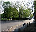
Canning Place/St Margarets churchyard
Image: © Andrew Tatlow
Taken: 22 Apr 2011
0.03 miles
2
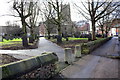
Footpath towards St Margaret's Church from Canning Place
There is an OS benchmark Image on the end of the near section of wall (left of entrance to paths).
Image: © Roger Templeman
Taken: 6 Jan 2015
0.03 miles
3
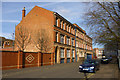
Industrial building, Canning Place, Leicester
A building, apparently unlisted nationally and locally (unless the local list has the street name wrong), with an interesting frontage. Over the main pedestrian entrance is a monogram, as usual hard to make out, and date 1872.
Image: © Robin Webster
Taken: 25 Mar 2016
0.03 miles
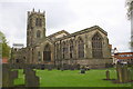
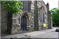
5
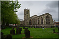
St Margaret's Church, Leicester
It is a Grade I listed building.
Parts of the transept date from c. 1200, and parts of the aisles from the late 13th century. Most of the church was rebuilt in Perpendicular style c. 1444, under William Alnwick, the Bishop of Lincoln. The west tower, which is 108 feet (33 m) high, was built at that time. There was a Victorian restoration by George Gilbert Scott in 1860, and another in 1881 by George Edmund Street.
https://en.wikipedia.org/wiki/St_Margaret%27s_Church,_Leicester
Image: © Brian Deegan
Taken: 27 Apr 2024
0.03 miles
6
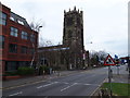
Leicester - City Centre
A view of St Margaret's Anglican Church at the side of St Margaret's Way. This is the point at which the A6 from the north meets Leicester's inner ring road (the Burley's Way/Vaughan Way stretch). Between the two most prominient buildings in the picture lies Canning Place. There is however, no vehicular access to or from it now for traffic safety reasons.
Image: © David Hallam-Jones
Taken: 31 Mar 2012
0.04 miles
7
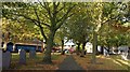
Path through St Margaret's churchyard, Leicester
Parts of the church date back to c.1200, most of the church was rebuilt in Perpendicular style c.1444. It is a Grade I listed building.
Image: © Mat Fascione
Taken: 14 Oct 2017
0.04 miles
8

War memorial and the Parish Church of St Margaret
Image: © Mat Fascione
Taken: 24 Feb 2019
0.04 miles
9
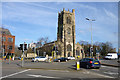
St. Margaret's church, Leicester
A mainly 15th century grade I listed building.
Image: © Robin Webster
Taken: 25 Mar 2016
0.04 miles
10
Door in west face of St Margaret's Church
See https://www.bench-marks.org.uk/bm26167 for details of an old Ordnance Survey benchmark which was cut here, but no longer to be seen
Image: © Roger Templeman
Taken: 11 May 2018
0.05 miles