IMAGES TAKEN NEAR TO
Willow Drive, MELTON MOWBRAY, LE13 1UA
Introduction
This page details the photographs taken nearby to Willow Drive, LE13 1UA by members of the Geograph project.
The Geograph project started in 2005 with the aim of publishing, organising and preserving representative images for every square kilometre of Great Britain, Ireland and the Isle of Man.

There are currently over 7.5m images from over14,400 individuals and you can help contribute to the project by visiting https://www.geograph.org.uk
Image Map
Images are licensed for reuse under creativecommons.org/licenses/by-sa/2.0
Notes
- Clicking on the map will re-center to the selected point.
- The higher the marker number, the further away the image location is from the centre of the postcode.
Image Listing (49 Images Found)
Images are licensed for reuse under creativecommons.org/licenses/by-sa/2.0
Image
Details
Distance
1
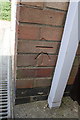
Benchmark on #32 Redwood Avenue
Ordnance Survey cut mark benchmark described on the Bench Mark Database at http://www.bench-marks.org.uk/bm42501
Image: © Roger Templeman
Taken: 10 Apr 2012
0.03 miles
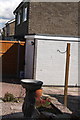
2

#32 Redwood Avenue
There is an OS benchmark Image on the front corner on the side of the garage left of the white downpipe
Image: © Roger Templeman
Taken: 10 Apr 2012
0.03 miles
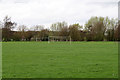
3
Walking the dog in Melton Country Park
The houses are in Redwood Avenue.
Image: © Kate Jewell
Taken: 6 Apr 2014
0.06 miles
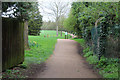
4

Melton Country Park
Houses on Laycock Avenue to the left. This path leads to the Willow Drive car park.
Image: © Kate Jewell
Taken: 6 Apr 2014
0.07 miles
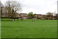
5
Playing fields, Melton Country Park
Easily accessed from the housing estates both sides of the Country Park so well used at weekends and during school holidays.
Image: © Kate Jewell
Taken: 6 Apr 2014
0.08 miles
6
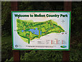
Information map, Melton Country Park
You won't get lost here, there are several of these signs dotted around the park.
Image: © Kate Jewell
Taken: 6 Apr 2014
0.09 miles
7
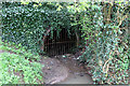
Culverted "brook" in Melton Country Park
This short stream/drainage ditch shows on the OS maps but has been buried in the Country Park. It emerges here for about 20 metres or so just to disappear into another tunnel. I presume it joins the Scalford Brook somewhere near King's Road.
Image: © Kate Jewell
Taken: 6 Apr 2014
0.09 miles
8
Entrance to Melton Country Park . . .
. . . from the Snow Hill footpath
Image: © Kate Jewell
Taken: 6 Apr 2014
0.10 miles
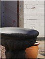
9
Detached garage of #2 Redwood Avenue
There is an OS benchmark Image on the garage seen above the birdbath
Image: © Roger Templeman
Taken: 10 Apr 2012
0.10 miles
10
Benchmark on garage of #2 Redwood Avenue
Ordnance Survey cut mark benchmark described on the Bench Mark Database at http://www.bench-marks.org.uk/bm42502
Image: © Roger Templeman
Taken: 10 Apr 2012
0.10 miles