IMAGES TAKEN NEAR TO
Waterside Close, MELTON MOWBRAY, LE13 1PF
Introduction
This page details the photographs taken nearby to Waterside Close, LE13 1PF by members of the Geograph project.
The Geograph project started in 2005 with the aim of publishing, organising and preserving representative images for every square kilometre of Great Britain, Ireland and the Isle of Man.

There are currently over 7.5m images from over14,400 individuals and you can help contribute to the project by visiting https://www.geograph.org.uk
Image Map (Loading...)


Getting Data...Please wait
Leaflet Map data © OpenStreetMap
Images are licensed for reuse under creativecommons.org/licenses/by-sa/2.0
Notes
- Clicking on the map will re-center to the selected point.
- The higher the marker number, the further away the image location is from the centre of the postcode.
Image Listing (43 Images Found)
Images are licensed for reuse under creativecommons.org/licenses/by-sa/2.0
Image
Details
Distance
2
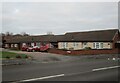
#122 Redwood Avenue
There is an OS benchmark Image on the near corner of the house above the gravelled approach to the garage
Image: © Roger Templeman
Taken: 10 Apr 2012
0.06 miles
3
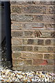
Benchmark on #122 Redwood Avenue
Ordnance Survey cut mark benchmark described on the Bench Mark Database at http://www.bench-marks.org.uk/bm42499
Image: © Roger Templeman
Taken: 10 Apr 2012
0.06 miles
4
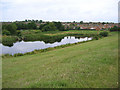
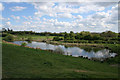
Overflow pond in Melton Country Park
Taken from the top of the dam looking south west. The main lake discharges into this pond which in turn overflows over a sluice centre left. Note the proximity of the housing.
Image: © Kate Jewell
Taken: 1 Aug 2005
0.07 miles
5
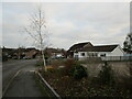
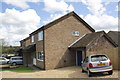
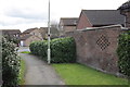
Housing, Redwood Avenue, Melton Mowbray
Image: © Jonathan Thacker
Taken: 21 Dec 2021
0.07 miles
6
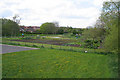
Small bottom lake ? Melton Country Park
This small lake is fed from the large middle lake via a sluice through the dam. It, in turn, feeds the Scalford Brook through a sluice, (left far bank). This is all part of the Melton Mowbray flood defence system.
Image: © Kate Jewell
Taken: 25 Apr 2009
0.10 miles
7
Redwood Avenue allotments
Not what you would expect in a Country Park but there are two allotment areas in Melton Country Park. These, at Redwood Avenue, are immaculate, not surprising as they are on public view all the time!
The other plots are at the end of Doctor's Lane on the south western side of the Park, see Image
Image: © Kate Jewell
Taken: 25 Apr 2009
0.11 miles
8
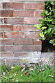
Benchmark on wall outside #115 Redwood Avenue
Ordnance Survey cut mark benchmark described on the Bench Mark Database at http://www.bench-marks.org.uk/bm42498
Image: © Roger Templeman
Taken: 10 Apr 2012
0.12 miles

10
Wall and footpath outside #115 Redwood Avenue
There is an OS benchmark Image on the wall angle at the right hand side of the image
Image: © Roger Templeman
Taken: 10 Apr 2012
0.12 miles