IMAGES TAKEN NEAR TO
Balmoral Road, MELTON MOWBRAY, LE13 1JN
Introduction
This page details the photographs taken nearby to Balmoral Road, LE13 1JN by members of the Geograph project.
The Geograph project started in 2005 with the aim of publishing, organising and preserving representative images for every square kilometre of Great Britain, Ireland and the Isle of Man.

There are currently over 7.5m images from over14,400 individuals and you can help contribute to the project by visiting https://www.geograph.org.uk
Image Map (Loading...)


Getting Data...Please wait
Leaflet Map data © OpenStreetMap
Images are licensed for reuse under creativecommons.org/licenses/by-sa/2.0
Notes
- Clicking on the map will re-center to the selected point.
- The higher the marker number, the further away the image location is from the centre of the postcode.
Image Listing (22 Images Found)
Images are licensed for reuse under creativecommons.org/licenses/by-sa/2.0
Image
Details
Distance
1
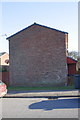
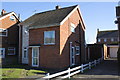
Dieppe Way face of #22 Dieppe Way
There is an OS benchmark Image on this face of the house at the junction with the wooden fence behind the car
Image: © Roger Templeman
Taken: 2 Apr 2013
0.06 miles
2
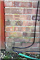
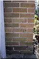
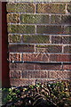
Benchmark on #22 Dieppe Way
Ordnance Survey cut mark benchmark described on the Bench Mark Database at http://www.bench-marks.org.uk/bm47961
Image: © Roger Templeman
Taken: 2 Apr 2013
0.06 miles
3
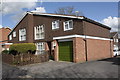
#89 Yew Tree Crescent
There is an OS benchmark Image on the front side corner of the integral garage
Image: © Roger Templeman
Taken: 10 Apr 2012
0.08 miles
4
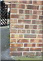
Benchmark on #89 Yew Tree Crescent
Ordnance Survey cut mark benchmark described on the Bench Mark Database at http://www.bench-marks.org.uk/bm42497
Image: © Roger Templeman
Taken: 10 Apr 2012
0.08 miles
5
Benchmark on Catherine Dalley House, Scalford Road
Ordnance Survey cut mark benchmark described on the Bench Mark Database at http://www.bench-marks.org.uk/bm42495
Image: © Roger Templeman
Taken: 10 Apr 2012
0.11 miles
6
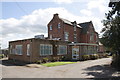
Catherine Dalley House, Scalford Road
The House is a carehome owned by Leicestershire County Council. There is an OS benchmark Image on the side of the single storey extension near the front corner.
Image: © Roger Templeman
Taken: 10 Apr 2012
0.11 miles
7
Electricity sub station, Scalford Road
Image: © Alex McGregor
Taken: 29 Sep 2012
0.12 miles
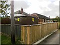
8
#44 Blenheim Road and car parking area
There is an OS benchmark Image on this side face of the house on the corner from which the wooden fence starts
Image: © Roger Templeman
Taken: 2 Apr 2013
0.15 miles
9
Benchmark on #44 Blenheim Walk
Ordnance Survey cut mark benchmark described on the Bench Mark Database at http://www.bench-marks.org.uk/bm47960
Image: © Roger Templeman
Taken: 2 Apr 2013
0.15 miles
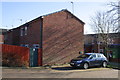
10
#31 Tennyson Way
There is an OS benchmark Image on the side of the house at the near corner
Image: © Roger Templeman
Taken: 2 Apr 2013
0.16 miles