IMAGES TAKEN NEAR TO
Dieppe Way, MELTON MOWBRAY, LE13 1JJ
Introduction
This page details the photographs taken nearby to Dieppe Way, LE13 1JJ by members of the Geograph project.
The Geograph project started in 2005 with the aim of publishing, organising and preserving representative images for every square kilometre of Great Britain, Ireland and the Isle of Man.

There are currently over 7.5m images from over14,400 individuals and you can help contribute to the project by visiting https://www.geograph.org.uk
Image Map (Loading...)


Getting Data...Please wait
Leaflet Map data © OpenStreetMap
Images are licensed for reuse under creativecommons.org/licenses/by-sa/2.0
Notes
- Clicking on the map will re-center to the selected point.
- The higher the marker number, the further away the image location is from the centre of the postcode.
Image Listing (35 Images Found)
Images are licensed for reuse under creativecommons.org/licenses/by-sa/2.0
Image
Details
Distance
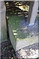
1
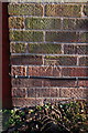
Benchmark on #44 Blenheim Walk
Ordnance Survey cut mark benchmark described on the Bench Mark Database at http://www.bench-marks.org.uk/bm47960
Image: © Roger Templeman
Taken: 2 Apr 2013
0.02 miles
2
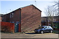
#44 Blenheim Road and car parking area
There is an OS benchmark Image on this side face of the house on the corner from which the wooden fence starts
Image: © Roger Templeman
Taken: 2 Apr 2013
0.02 miles
3
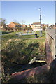
Dieppe Way with culvert over stream in foreground
There is an OS rivet benchmark Image on the brick portion of the culvert top at the bootm of the image
Image: © Roger Templeman
Taken: 2 Apr 2013
0.09 miles
4

Benchmark on top of culvert on Dieppe Way
Ordnance Survey rivet benchmark described on the Bench Mark Database at http://www.bench-marks.org.uk/bm47965
Image: © Roger Templeman
Taken: 2 Apr 2013
0.11 miles
7
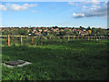
Kipling Drive estate, Melton
Looking east from Nottingham Road to the Kipling Drive estate, built in the 1980s. All the roads are named after poets.
Image: © Kate Jewell
Taken: 20 Oct 2005
0.12 miles
8
Benchmark on low bridge parapet on Kipling Drive
Ordnance Survey rivet benchmark described on the Bench Mark Database at http://www.bench-marks.org.uk/bm47964
Image: © Roger Templeman
Taken: 2 Apr 2013
0.13 miles
9
Bridge over stream on Kipling Drive
The bridge has low concrete parapets with railings above. There is an OS benchmark Image on top of the parapet at its left hand end.
Image: © Roger Templeman
Taken: 2 Apr 2013
0.13 miles
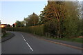
10
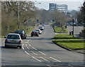
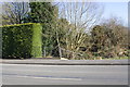
Nottingham Road heading into Melton Mowbray
Image: © Mat Fascione
Taken: 29 Mar 2014
0.13 miles