IMAGES TAKEN NEAR TO
Cedar Drive, MELTON MOWBRAY, LE13 0PA
Introduction
This page details the photographs taken nearby to Cedar Drive, LE13 0PA by members of the Geograph project.
The Geograph project started in 2005 with the aim of publishing, organising and preserving representative images for every square kilometre of Great Britain, Ireland and the Isle of Man.

There are currently over 7.5m images from over14,400 individuals and you can help contribute to the project by visiting https://www.geograph.org.uk
Image Map (Loading...)


Getting Data...Please wait
Leaflet Map data © OpenStreetMap
Images are licensed for reuse under creativecommons.org/licenses/by-sa/2.0
Notes
- Clicking on the map will re-center to the selected point.
- The higher the marker number, the further away the image location is from the centre of the postcode.
Image Listing (38 Images Found)
Images are licensed for reuse under creativecommons.org/licenses/by-sa/2.0
Image
Details
Distance
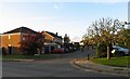

5
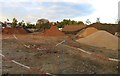
Assorted piles
Part of the Rossiter Way building site.
Image: © Andrew Tatlow
Taken: 21 Oct 2010
0.10 miles
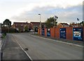
6
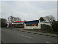
Filling station, Nottingham Road, Melton Mowbray
Image: © Jonathan Thacker
Taken: 21 Dec 2021
0.11 miles
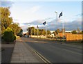
7
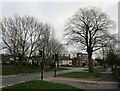
Nottingham Road, Melton Mowbray
The Crescent going off to the left.
Image: © Jonathan Thacker
Taken: 21 Dec 2021
0.12 miles
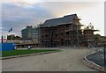
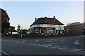
9
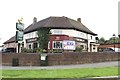
The Welby
Public house on Nottingham Road and Welby Lane.
Image: © Andrew Abbott
Taken: 20 Aug 2017
0.12 miles