IMAGES TAKEN NEAR TO
Brightside Avenue, MELTON MOWBRAY, LE13 0JY
Introduction
This page details the photographs taken nearby to Brightside Avenue, LE13 0JY by members of the Geograph project.
The Geograph project started in 2005 with the aim of publishing, organising and preserving representative images for every square kilometre of Great Britain, Ireland and the Isle of Man.

There are currently over 7.5m images from over14,400 individuals and you can help contribute to the project by visiting https://www.geograph.org.uk
Image Map
Images are licensed for reuse under creativecommons.org/licenses/by-sa/2.0
Notes
- Clicking on the map will re-center to the selected point.
- The higher the marker number, the further away the image location is from the centre of the postcode.
Image Listing (39 Images Found)
Images are licensed for reuse under creativecommons.org/licenses/by-sa/2.0
Image
Details
Distance
1
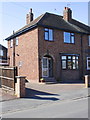
#15 Dorothy Avenue
There is an OS benchmark Image on the side of the house near the front corner
Image: © Roger Templeman
Taken: 2 Apr 2013
0.03 miles
2
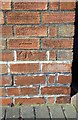
Benchmark on #15 Dorothy Avenue
Ordnance Survey cut mark benchmark described on the Bench Mark Database at http://www.bench-marks.org.uk/bm47949
Image: © Roger Templeman
Taken: 2 Apr 2013
0.03 miles
3

View From the Embankment
And no sign of the houses of parliament anywhere! This view is taken from the permissive path on the old Great Northern and London and North Western Joint Railway Line embankment that served Melton Mowbray North station. The foreground houses are on a triangular plot of land beside Asfordby Road. The houses beyond are on Brightside Avenue, Dorothy Avenue and Rudbeck Avenue. Hawthorn and Elder frame the photo.
Image: © Martin Addison
Taken: 25 Apr 2009
0.06 miles
4
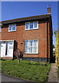
#2 Rockingham Drive
There is an OS benchmark Image on black-coated bricks on the side of the house near the front corner
Image: © Roger Templeman
Taken: 2 Apr 2013
0.10 miles
5
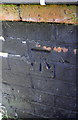
Benchmark on #2 Rockingham Drive
Ordnance Survey cut mark benchmark described on the Bench Mark Database at http://www.bench-marks.org.uk/bm47950
Image: © Roger Templeman
Taken: 2 Apr 2013
0.10 miles
6
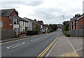
West along Asfordby Road, Melton Mowbray
The A6006 Asfordby Road heads away from the town centre.
Image: © Jaggery
Taken: 23 Aug 2014
0.15 miles
7

Asfordby Road in Melton Mowbray
This is the western edge of the town of Melton Mowbray.
Image: © Mat Fascione
Taken: 29 Mar 2014
0.15 miles
8
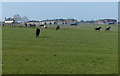
Horses near the Melton Mowbray Army Remount Depot
Image: © Mat Fascione
Taken: 29 Mar 2014
0.16 miles
9
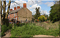
Beside the Embankment
A short terrace of houses served only by a path sit on a triangle of land between the old Great Northern and London and North Western Joint Railway embankment and Asfordby Road. The terrace was built in 1878.
Image: © Martin Addison
Taken: 25 Apr 2009
0.16 miles
10
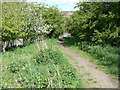
Path onto the embankment
The embankment of the former Great Northern/London and North Western Railways' joint line provides a useful walkway through the western part of town, including a river crossing Image Not a formal right of way, it is signed as a permissive footpath
Image: © Alan Murray-Rust
Taken: 25 Apr 2009
0.17 miles