IMAGES TAKEN NEAR TO
West Avenue, MELTON MOWBRAY, LE13 0JH
Introduction
This page details the photographs taken nearby to West Avenue, LE13 0JH by members of the Geograph project.
The Geograph project started in 2005 with the aim of publishing, organising and preserving representative images for every square kilometre of Great Britain, Ireland and the Isle of Man.

There are currently over 7.5m images from over14,400 individuals and you can help contribute to the project by visiting https://www.geograph.org.uk
Image Map (Loading...)


Getting Data...Please wait
Leaflet Map data © OpenStreetMap
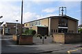
Images are licensed for reuse under creativecommons.org/licenses/by-sa/2.0
Notes
- Clicking on the map will re-center to the selected point.
- The higher the marker number, the further away the image location is from the centre of the postcode.
Image Listing (13 Images Found)
Images are licensed for reuse under creativecommons.org/licenses/by-sa/2.0
Image
Details
Distance
1
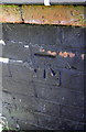
Benchmark on #2 Rockingham Drive
Ordnance Survey cut mark benchmark described on the Bench Mark Database at http://www.bench-marks.org.uk/bm47950
Image: © Roger Templeman
Taken: 2 Apr 2013
0.16 miles
2
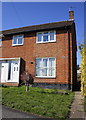
#2 Rockingham Drive
There is an OS benchmark Image on black-coated bricks on the side of the house near the front corner
Image: © Roger Templeman
Taken: 2 Apr 2013
0.16 miles
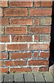
3
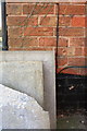
Benchmark on #14 Sysonby Street
Ordnance Survey cut mark benchmark described on the Bench Mark Database at http://www.bench-marks.org.uk/bm47951
Image: © Roger Templeman
Taken: 2 Apr 2013
0.16 miles
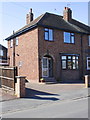
4
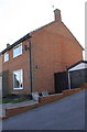
#14 Sysonby Street
There is an OS benchmark Image on the side of the house near the front corner above some leaning paving stones
Image: © Roger Templeman
Taken: 2 Apr 2013
0.16 miles
5
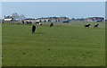
Horses near the Melton Mowbray Army Remount Depot
Image: © Mat Fascione
Taken: 29 Mar 2014
0.17 miles
7
Benchmark on #15 Dorothy Avenue
Ordnance Survey cut mark benchmark described on the Bench Mark Database at http://www.bench-marks.org.uk/bm47949
Image: © Roger Templeman
Taken: 2 Apr 2013
0.20 miles
8
#15 Dorothy Avenue
There is an OS benchmark Image on the side of the house near the front corner
Image: © Roger Templeman
Taken: 2 Apr 2013
0.20 miles
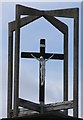
9
St Peters Welby Lane Melton Mowbray
A large modern RC church
Image: © Andrew Tatlow
Taken: 19 Aug 2006
0.20 miles
10

View From the Embankment
And no sign of the houses of parliament anywhere! This view is taken from the permissive path on the old Great Northern and London and North Western Joint Railway Line embankment that served Melton Mowbray North station. The foreground houses are on a triangular plot of land beside Asfordby Road. The houses beyond are on Brightside Avenue, Dorothy Avenue and Rudbeck Avenue. Hawthorn and Elder frame the photo.
Image: © Martin Addison
Taken: 25 Apr 2009
0.23 miles