IMAGES TAKEN NEAR TO
Asfordby Road, MELTON MOWBRAY, LE13 0HT
Introduction
This page details the photographs taken nearby to Asfordby Road, LE13 0HT by members of the Geograph project.
The Geograph project started in 2005 with the aim of publishing, organising and preserving representative images for every square kilometre of Great Britain, Ireland and the Isle of Man.

There are currently over 7.5m images from over14,400 individuals and you can help contribute to the project by visiting https://www.geograph.org.uk
Image Map (Loading...)


Getting Data...Please wait
Leaflet Map data © OpenStreetMap
Images are licensed for reuse under creativecommons.org/licenses/by-sa/2.0
Notes
- Clicking on the map will re-center to the selected point.
- The higher the marker number, the further away the image location is from the centre of the postcode.
Image Listing (70 Images Found)
Images are licensed for reuse under creativecommons.org/licenses/by-sa/2.0
Image
Details
Distance
1
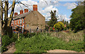
Beside the Embankment
A short terrace of houses served only by a path sit on a triangle of land between the old Great Northern and London and North Western Joint Railway embankment and Asfordby Road. The terrace was built in 1878.
Image: © Martin Addison
Taken: 25 Apr 2009
0.02 miles
2
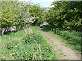
Path onto the embankment
The embankment of the former Great Northern/London and North Western Railways' joint line provides a useful walkway through the western part of town, including a river crossing Image Not a formal right of way, it is signed as a permissive footpath
Image: © Alan Murray-Rust
Taken: 25 Apr 2009
0.04 miles
3
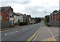
West along Asfordby Road, Melton Mowbray
The A6006 Asfordby Road heads away from the town centre.
Image: © Jaggery
Taken: 23 Aug 2014
0.04 miles
5
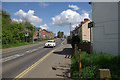
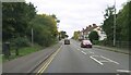
Asfordby Road, Melton Mowbray
A classic Jaguar heads out of the town on the A6006.
Image: © Stephen McKay
Taken: 25 Apr 2009
0.08 miles
6

View From the Embankment
And no sign of the houses of parliament anywhere! This view is taken from the permissive path on the old Great Northern and London and North Western Joint Railway Line embankment that served Melton Mowbray North station. The foreground houses are on a triangular plot of land beside Asfordby Road. The houses beyond are on Brightside Avenue, Dorothy Avenue and Rudbeck Avenue. Hawthorn and Elder frame the photo.
Image: © Martin Addison
Taken: 25 Apr 2009
0.08 miles
7
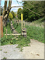
Footpath and stile
The stile marks the point at which the footpath leaves its alignment along the old railway embankment (right). It used to head across fields at this point, but these have now succumbed to housing development Image where the right of way has become a road for a short distance.
Image: © Alan Murray-Rust
Taken: 25 Apr 2009
0.10 miles
8
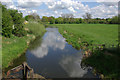
River Eye, near Melton Mowbray
Looking upstream from the footbridge that has replaced a former railway bridge that once carried the Leicester - Newark railway, the remains of which can be seen in the foreground. The Wreake is a tributary of the River Soar which it joins at Rothley.
Image: © Stephen McKay
Taken: 25 Apr 2009
0.10 miles
9
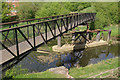
Footbridge over the River Wreake
This footbridge has replaced a former railway bridge, the piers of which can still be seen. The line that once ran here was part of an extensive network that connected Nottingham, Newark, Leicester, Market Harborough and Peterborough, originally operated jointly by the Great Northern and London & North Western Railways and now all gone. In fact, regular passenger services were withdrawn as long ago as 1953, although the line continued to be used for freight and the occasional summer holiday special into the 1960s. An excellent account of this fascinating line - the reasons it was built and why it declined - can be found in P. Howard Anderson's book 'Forgotten Railways - The East Midlands', published by David & Charles in 1973.
Image: © Stephen McKay
Taken: 25 Apr 2009
0.10 miles
10

Geographing from a Footbridge
The footbridge crosses the River Wreake along the line of a dismantled railway.
The Geographers visible are Julia Hood (at time of picture not a geographer!), Martin Addison (just), Alan Murray-Rust and Stephen McKay.
Image: © David Lally
Taken: 25 Apr 2009
0.11 miles