IMAGES TAKEN NEAR TO
Peartree Avenue, LOUGHBOROUGH, LE12 9JN
Introduction
This page details the photographs taken nearby to Peartree Avenue, LE12 9JN by members of the Geograph project.
The Geograph project started in 2005 with the aim of publishing, organising and preserving representative images for every square kilometre of Great Britain, Ireland and the Isle of Man.

There are currently over 7.5m images from over14,400 individuals and you can help contribute to the project by visiting https://www.geograph.org.uk
Image Map (Loading...)


Getting Data...Please wait
Leaflet Map data © OpenStreetMap
Images are licensed for reuse under creativecommons.org/licenses/by-sa/2.0
Notes
- Clicking on the map will re-center to the selected point.
- The higher the marker number, the further away the image location is from the centre of the postcode.
Image Listing (8 Images Found)
Images are licensed for reuse under creativecommons.org/licenses/by-sa/2.0
Image
Details
Distance
1
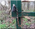
Padlocks and chain on Coach Roadgate in the woods
Image: © Andrew Tatlow
Taken: 8 Jan 2020
0.10 miles
2
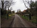
Coach Road gate in the woods from east
See
Image
for close up of gate fastening.
Image: © Andrew Tatlow
Taken: 8 Jan 2020
0.10 miles
3
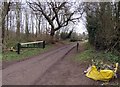
Coach Road gate in the woods from west
See
Image
for close up of gate fastening.
Image: © Andrew Tatlow
Taken: 8 Jan 2020
0.10 miles
4
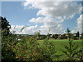
View south to Ives Head
I'm standing at the grid reference looking south across Newcroft School field, Shepshed, towards Ives Head, on the northern slopes of Charnwood Forest. The estate was built in the 1970s-1980s and so does not appear on the 1940's OS maps.
Image: © Sue Hutton
Taken: Unknown
0.18 miles