IMAGES TAKEN NEAR TO
Quaker Road, LOUGHBOROUGH, LE12 7SA
Introduction
This page details the photographs taken nearby to Quaker Road, LE12 7SA by members of the Geograph project.
The Geograph project started in 2005 with the aim of publishing, organising and preserving representative images for every square kilometre of Great Britain, Ireland and the Isle of Man.

There are currently over 7.5m images from over14,400 individuals and you can help contribute to the project by visiting https://www.geograph.org.uk
Image Map (Loading...)


Getting Data...Please wait
Leaflet Map data © OpenStreetMap
Images are licensed for reuse under creativecommons.org/licenses/by-sa/2.0
Notes
- Clicking on the map will re-center to the selected point.
- The higher the marker number, the further away the image location is from the centre of the postcode.
Image Listing (14 Images Found)
Images are licensed for reuse under creativecommons.org/licenses/by-sa/2.0
Image
Details
Distance
1
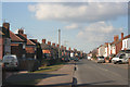
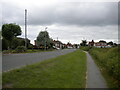
Sileby, Leicestershire
Looking along Cossington Road. Sileby is a large village in the Soar Valley.
Image: © Kate Jewell
Taken: 4 Mar 2006
0.10 miles
2
Chalfont Drive, Sileby
Off Cossington Road.
Image: © Richard Vince
Taken: 19 Jun 2021
0.11 miles
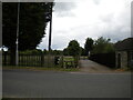
3
Cossington Road, Sileby, Leics.
The "Sileby Entrance" into Cossington Meadows Nature Reserve can be found between two houses opposite the junction of Charles street and Cossington Road.
Image: © David Hallam-Jones
Taken: 30 May 2016
0.11 miles
4
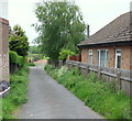
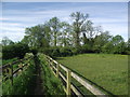
Cossington Road/Charles Street Vicinity, Sileby, Leics.
With the off-street "Sileby entrance" into Cossington Meadows Nature Reserve 100-150 metres behind the photographer, would-be visitors are must now follow this footpath, sandwiched between two stout wooden fences.
Image: © David Hallam-Jones
Taken: 30 May 2016
0.13 miles
5
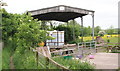
Cossington Meadows Nature Reserve, Sileby, Leics.
The "Sileby Entrance" into this nature reserve lies 500 metres or so behind the photographer, opposite the junction of two roads, i.e. Cossington Road and Charles Street. At this point however, visitors are obliged to continue along a path between some buildings belonging to the owners of a couple of small-holdings. The path follows a southwesterly course.
Image: © David Hallam-Jones
Taken: 30 May 2016
0.14 miles
6
Footpath from Cossington Road to Syston Road
Image: © Tim Glover
Taken: 20 May 2017
0.15 miles
7
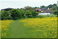
Cossington Meadows Nature Reserve, Sileby, Leics.
A backwards glance from near Middle Meadow, before visitors continue onwards towards Lower Meadow. Such a glance provides this buttercup embellished view towards houses on Cossington Road, i.e. the main road between Sileby and Cossington.
Image: © David Hallam-Jones
Taken: 30 May 2016
0.15 miles
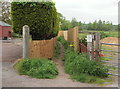
8
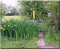
Cossington Meadows Nature Reserve, Sileby, Leics.
A clump of irises and a kissing gate in the vicinity of Lower Meadow.
Image: © David Hallam-Jones
Taken: 30 May 2016
0.16 miles
9
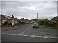
Cossington Road, Sileby
Entering the village from the south.
Image: © Richard Vince
Taken: 19 Jun 2021
0.17 miles
10
Public footpath off Cossington Road, Sileby
At the south end of the village, accessed from the road by the stile in the centre of the picture.
Image: © Richard Vince
Taken: 19 Jun 2021
0.19 miles