IMAGES TAKEN NEAR TO
Leicester Road, LOUGHBOROUGH, LE12 7AJ
Introduction
This page details the photographs taken nearby to Leicester Road, LE12 7AJ by members of the Geograph project.
The Geograph project started in 2005 with the aim of publishing, organising and preserving representative images for every square kilometre of Great Britain, Ireland and the Isle of Man.

There are currently over 7.5m images from over14,400 individuals and you can help contribute to the project by visiting https://www.geograph.org.uk
Image Map
Images are licensed for reuse under creativecommons.org/licenses/by-sa/2.0
Notes
- Clicking on the map will re-center to the selected point.
- The higher the marker number, the further away the image location is from the centre of the postcode.
Image Listing (104 Images Found)
Images are licensed for reuse under creativecommons.org/licenses/by-sa/2.0
Image
Details
Distance
1
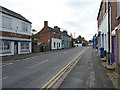
South along Leicester Road, Mountsorrel
A view south down the main road in the town.
Image: © Richard Law
Taken: 14 Aug 2019
0.01 miles
2
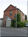
Former United Methodist Chapel, Mountsorrel
Built in 1864 according to the stone high on the gable wall, and now converted to commercial office premises.
Image: © Richard Law
Taken: 14 Aug 2019
0.04 miles
3
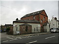
Former chapel, Mountsorrel
Now in commercial use.
Image: © Jonathan Thacker
Taken: 5 Mar 2022
0.04 miles
4
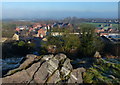
View across Mountsorrel from Castle Hill
Castle Hill is in the centre of Mountsorrel village. Castle Hill was the site of Mountsorrel Castle, built in 1080 and subsequently destroyed in 1217 on the orders of Henry II.
Image: © Mat Fascione
Taken: 4 Jan 2015
0.06 miles
5
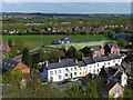
View across the village of Mountsorrel
This is the view from the war memorial on Castle Hill, towards the outdoor pitch at the Soar Valley Leisure Centre.
Image: © Mat Fascione
Taken: 26 Apr 2015
0.06 miles
6
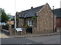
Parish Room, Mountsorrel
By the looks of it now a small council office, this was formerly the Parish Room and an Infant School, Dated 1847, it was Grade II listed https://britishlistedbuildings.co.uk/101228108-parish-room-with-walls-piers-gates-and-railings-mountsorrel#.XZrciEZKhPY & https://historicengland.org.uk/listing/the-list/list-entry/1228108 in 1984, along with the low walls, gates and railings.
Image: © Richard Law
Taken: 14 Aug 2019
0.06 miles
7

View across the village of Mountsorrel
This is the view from the war memorial on Castle Hill, looking east towards the houses on Little Lane.
Image: © Mat Fascione
Taken: 24 Feb 2019
0.07 miles
8

War memorial atop Castle Hill
http://en.wikipedia.org/wiki/Mountsorrel
Image: © Mat Fascione
Taken: 15 Jun 2008
0.07 miles
9
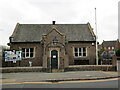
Mountsorrel Parish Room
A former school dating from 1847 https://historicengland.org.uk/listing/the-list/list-entry/1228108?section=official-list-entry
Image: © Jonathan Thacker
Taken: 5 Mar 2022
0.07 miles
10
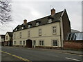
The Grapes, Mountsorrel
Onetime coaching in dated 1713 https://historicengland.org.uk/listing/the-list/list-entry/1287342?section=official-list-entry
Image: © Jonathan Thacker
Taken: 5 Mar 2022
0.07 miles