IMAGES TAKEN NEAR TO
Sand Martin Close, LOUGHBOROUGH, LE12 6YL
Introduction
This page details the photographs taken nearby to Sand Martin Close, LE12 6YL by members of the Geograph project.
The Geograph project started in 2005 with the aim of publishing, organising and preserving representative images for every square kilometre of Great Britain, Ireland and the Isle of Man.

There are currently over 7.5m images from over14,400 individuals and you can help contribute to the project by visiting https://www.geograph.org.uk
Image Map
Images are licensed for reuse under creativecommons.org/licenses/by-sa/2.0
Notes
- Clicking on the map will re-center to the selected point.
- The higher the marker number, the further away the image location is from the centre of the postcode.
Image Listing (11 Images Found)
Images are licensed for reuse under creativecommons.org/licenses/by-sa/2.0
Image
Details
Distance
1

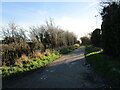
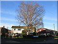
Grass field and the edge of East Leake
Image: © Jonathan Thacker
Taken: 25 Dec 2020
0.08 miles
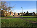
2
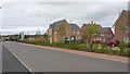
New housing on Lantern Lane
A new housing development on the outskirts of East Leake.
Image: © Peter Mackenzie
Taken: 29 Aug 2017
0.11 miles
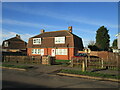
3
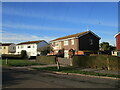
BISF houses, Lantern Lane, East Leake
British Iron and Steel Federation (BISF) houses were one of several designs of prefabricated houses constructed in Britain after the Second World War. These houses have had additional cladding to the upper floor to provide better insulation. However, as can be seen on the house in the centre of the picture this does not seem to be entirely successful as this and several other houses on the estate have cladding panels missing.
Image: © Jonathan Thacker
Taken: 25 Dec 2020
0.14 miles
5
BISF houses, Lantern Lane, East Leake
British Iron and Steel Federation (BISF) houses were one of several designs of prefabricated houses constructed in Britain after the Second World War. The house on the right (behind the tree) is in close to original condition with the steel panels showing on the upper floor. The house on the left has been clad to provide better insulation. https://en.wikipedia.org/wiki/BISF_house
Image: © Jonathan Thacker
Taken: 25 Dec 2020
0.19 miles
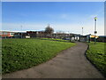
6
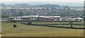
Schools, East Leake
Seen looking SW from the bridle path up to Hill Top Farm. Brand new PFI project, Harry Carlton Comprehensive, Lantern Lane Primary, together with a Leisure Centre. The old school site to the right is now being developed for housing.
Image: © Chris J Dixon
Taken: 8 Jul 2005
0.20 miles
7
Cornish houses, Lantern Lane, East Leake
Post war fabricated housing designed for the Central Cornwall Concrete & Artificial Stone Co.. Over 20,000 were built across Britain.
Image: © Jonathan Thacker
Taken: 25 Dec 2020
0.20 miles
8
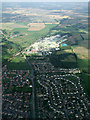
East Leake from the air
The gypsum works dominate the background. On approach to East Midlands Airport on a flight from Glasgow.
Image: © Thomas Nugent
Taken: 8 Sep 2014
0.20 miles
9
The Crescent, East Leake
Most of the houses in this picture are prefabricated houses of the type known as Cornish houses designed for the Central Cornwall Concrete & Artificial Stone Co.. Over 20,000 were built across Britain.
Image: © Jonathan Thacker
Taken: 25 Dec 2020
0.21 miles