IMAGES TAKEN NEAR TO
Sheppards Orchard, LOUGHBOROUGH, LE12 6TW
Introduction
This page details the photographs taken nearby to Sheppards Orchard, LE12 6TW by members of the Geograph project.
The Geograph project started in 2005 with the aim of publishing, organising and preserving representative images for every square kilometre of Great Britain, Ireland and the Isle of Man.

There are currently over 7.5m images from over14,400 individuals and you can help contribute to the project by visiting https://www.geograph.org.uk
Image Map
Images are licensed for reuse under creativecommons.org/licenses/by-sa/2.0
Notes
- Clicking on the map will re-center to the selected point.
- The higher the marker number, the further away the image location is from the centre of the postcode.
Image Listing (177 Images Found)
Images are licensed for reuse under creativecommons.org/licenses/by-sa/2.0
Image
Details
Distance
1
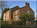
The Old Baptist Chapel
The main part of the building was built in 1781. It was enlarged in 1815 and the school rooms added in 1847, the date which appears in the gable. It was converted into a private dwelling in 1965 http://www.geograph.org.uk/photo/2733966. Listed Grade II.
Image: © Alan Murray-Rust
Taken: 12 Dec 2011
0.02 miles
2
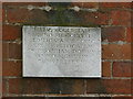
Stone on former Baptist Chapel
See http://www.geograph.org.uk/photo/2733965
The Latin inscription might suggest an old inscription, but it translates as follows:
R.I-S and E.I-S converted this church, built in 1781 and extended in the 19th century, into a private house in 1965
Image: © Alan Murray-Rust
Taken: 12 Dec 2011
0.02 miles
3
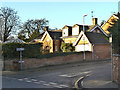
Former School, Far Street
Dated 1838, now a private house. The two dormer windows are modern additions, for which special permission must have been given as the building is listed Grade II.
Image: © Alan Murray-Rust
Taken: 12 Dec 2011
0.04 miles
4
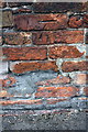
Benchmark on wall of Wysall Lane
Ordnance Survey cut mark benchmark described on the Bench Mark Database at http://www.bench-marks.org.uk/bm76026
Image: © Roger Templeman
Taken: 30 Apr 2016
0.04 miles
5
Wysall Lane
There is an OS benchmark Image on the wall of the garage about 5ft. left of the no-waiting sign
Image: © Roger Templeman
Taken: 30 Apr 2016
0.04 miles
7
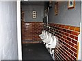
Semi open air loos at The Three Crowns
Image: © Alex McGregor
Taken: 23 Jan 2014
0.05 miles
8
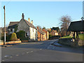
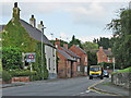
Far Street (eastern end)
The main road from Wymeswold to Melton Mowbray where it leaves the village centre.
Image: © Alan Murray-Rust
Taken: 12 Dec 2011
0.05 miles
9
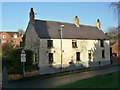
49 Far Street
This house probably dates from the early 18th century, and may be timber framed. Listed Grade II.
Image: © Alan Murray-Rust
Taken: 12 Dec 2011
0.05 miles
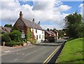
10
Wymeswold: the road to Melton
The A6006, here Far Street and further on East Road, seen from the corner of The Stockwell.
Image: © John Sutton
Taken: 14 Jul 2016
0.05 miles