IMAGES TAKEN NEAR TO
Brickcliffe Road, LOUGHBOROUGH, LE12 6JB
Introduction
This page details the photographs taken nearby to Brickcliffe Road, LE12 6JB by members of the Geograph project.
The Geograph project started in 2005 with the aim of publishing, organising and preserving representative images for every square kilometre of Great Britain, Ireland and the Isle of Man.

There are currently over 7.5m images from over14,400 individuals and you can help contribute to the project by visiting https://www.geograph.org.uk
Image Map (Loading...)


Getting Data...Please wait
Leaflet Map data © OpenStreetMap
Images are licensed for reuse under creativecommons.org/licenses/by-sa/2.0
Notes
- Clicking on the map will re-center to the selected point.
- The higher the marker number, the further away the image location is from the centre of the postcode.
Image Listing (16 Images Found)
Images are licensed for reuse under creativecommons.org/licenses/by-sa/2.0
Image
Details
Distance
1
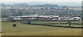
Schools, East Leake
Seen looking SW from the bridle path up to Hill Top Farm. Brand new PFI project, Harry Carlton Comprehensive, Lantern Lane Primary, together with a Leisure Centre. The old school site to the right is now being developed for housing.
Image: © Chris J Dixon
Taken: 8 Jul 2005
0.09 miles
4
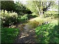
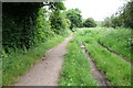
Ford on Sheep Plank Lane
Crossing Kingston Brook.
Image: © Ian Calderwood
Taken: 23 Sep 2018
0.15 miles
5
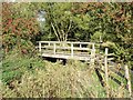
Footbridge by the ford on Sheep Plank Lane
Crossing Kingston Brook
Image: © Ian Calderwood
Taken: 23 Sep 2018
0.15 miles
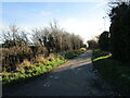
6
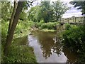
Ford on Sheep Plank Lane
This ford is found on Sheep Plank Lane a byway leading through Kingston Brook. In 2016 an application was made by East Leake Parish Council to the Rights of Way Officer at Nottinghamshire County Council to have the lane altered to a 'usable' footpath/cycleway and possibly excluding vehicles.
Image: © John Walton
Taken: 16 Jun 2019
0.15 miles
7
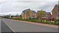
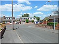
New housing on Lantern Lane
A new housing development on the outskirts of East Leake.
Image: © Peter Mackenzie
Taken: 29 Aug 2017
0.16 miles
8
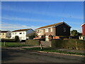
BISF houses, Lantern Lane, East Leake
British Iron and Steel Federation (BISF) houses were one of several designs of prefabricated houses constructed in Britain after the Second World War. These houses have had additional cladding to the upper floor to provide better insulation. However, as can be seen on the house in the centre of the picture this does not seem to be entirely successful as this and several other houses on the estate have cladding panels missing.
Image: © Jonathan Thacker
Taken: 25 Dec 2020
0.18 miles
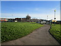
10
Carlton Crescent, East Leake
Large residential village near Loughborough, although it is actually in Nottinghamshire.
Image: © Stephen Sweeney
Taken: 20 Jun 2011
0.19 miles