IMAGES TAKEN NEAR TO
Main Street, LOUGHBOROUGH, LE12 5DF
Introduction
This page details the photographs taken nearby to Main Street, LE12 5DF by members of the Geograph project.
The Geograph project started in 2005 with the aim of publishing, organising and preserving representative images for every square kilometre of Great Britain, Ireland and the Isle of Man.

There are currently over 7.5m images from over14,400 individuals and you can help contribute to the project by visiting https://www.geograph.org.uk
Image Map
Images are licensed for reuse under creativecommons.org/licenses/by-sa/2.0
Notes
- Clicking on the map will re-center to the selected point.
- The higher the marker number, the further away the image location is from the centre of the postcode.
Image Listing (53 Images Found)
Images are licensed for reuse under creativecommons.org/licenses/by-sa/2.0
Image
Details
Distance
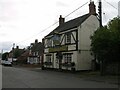
1
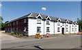
The Square, Long Whatton
Built in the mid 19th century by the Dawson family as residential accommodation for estate workers. In the form of a rectangular block surrounding a courtyard.
Image: © Alan Murray-Rust
Taken: 15 Jul 2018
0.01 miles
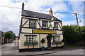
7
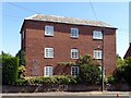
53, Main Street, Long Whatton
The road front seen here dates to the mid 18th century, but represents an addition to an older, 17th century, timber framed house http://www.geograph.org.uk/photo/5846042 . A door and rainwater head give dates of 1753 and 1755, probably defining the date of this range. Listed Grade II.
Image: © Alan Murray-Rust
Taken: 15 Jul 2018
0.03 miles
8
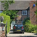
53, Main Street, Long Whatton
This is the older, 17th century, timber framed house wing, to which a noew wing fronting the road was added in the mid-18th century http://www.geograph.org.uk/photo/5845965 . A door and rainwater head give dates of 1753 and 1755, probably defining the date of this range. Listed Grade II.
Image: © Alan Murray-Rust
Taken: 15 Jul 2018
0.03 miles
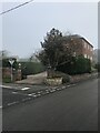
9
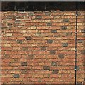
Chequer pattern brickwork, Malt Roow
In a variant of Flemish bond, probably early/mid 19th century. It was common at the period to have the headers in a contrasting colour, in this case dark vitreous ones, but normally they form a regular pattern. Here only about half the headers are dark, and their placing is entirely random. See http://www.geograph.org.uk/photo/5847910 for location.
Image: © Alan Murray-Rust
Taken: 15 Jul 2018
0.04 miles
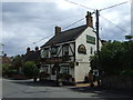
10
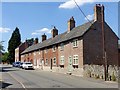
17-21 Main Street, Long Whatton
A row of cottages, known locally as Malt Row, possibly built as estate cottages for Whatton House. A feature is the use of dark vitreous headers in the brickwork, http://www.geograph.org.uk/photo/5847950 , to produce a random chequer pattern.
Image: © Alan Murray-Rust
Taken: 15 Jul 2018
0.05 miles