IMAGES TAKEN NEAR TO
Oxford Street, LOUGHBOROUGH, LE11 5DP
Introduction
This page details the photographs taken nearby to Oxford Street, LE11 5DP by members of the Geograph project.
The Geograph project started in 2005 with the aim of publishing, organising and preserving representative images for every square kilometre of Great Britain, Ireland and the Isle of Man.

There are currently over 7.5m images from over14,400 individuals and you can help contribute to the project by visiting https://www.geograph.org.uk
Image Map (Loading...)


Getting Data...Please wait
Leaflet Map data © OpenStreetMap
Images are licensed for reuse under creativecommons.org/licenses/by-sa/2.0
Notes
- Clicking on the map will re-center to the selected point.
- The higher the marker number, the further away the image location is from the centre of the postcode.
Image Listing (102 Images Found)
Images are licensed for reuse under creativecommons.org/licenses/by-sa/2.0
Image
Details
Distance
1
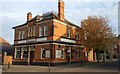
Paget Arms
A public house on the corner of Paget Street and Oxford Street in Loughborough.
Image: © Mat Fascione
Taken: 5 Nov 2018
0.03 miles
2
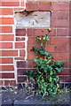
Benchmark on #50 Paget Street
Ordnance Survey cut mark benchmark described on the Bench Mark Database at http://www.bench-marks.org.uk/bm67216
Image: © Roger Templeman
Taken: 20 May 2015
0.04 miles
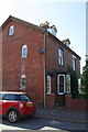
3
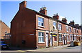
Paget Street houses at Oxford Street junction
There is an OS benchmark Image on the Oxford Street face of the nearest house, at its rear corner left of a parking restriction sign
Image: © Roger Templeman
Taken: 20 May 2015
0.04 miles
4

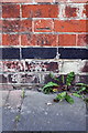
Benchmark on #11 Hastings Street
Ordnance Survey cut mark benchmark described on the Bench Mark Database at http://www.bench-marks.org.uk/bm66884
Image: © Roger Templeman
Taken: 20 May 2015
0.10 miles
5

#15 Hastings Street
There is an OS benchmark Image on the front of the house near its left hand corner, and right of the pole of a parking restriction sign
Image: © Roger Templeman
Taken: 20 May 2015
0.11 miles
6
Benchmark on #132 Station Street
Ordnance Survey cut mark benchmark described on the Bench Mark Database at http://www.bench-marks.org.uk/bm67217
Image: © Roger Templeman
Taken: 20 May 2015
0.12 miles
7
#132 Station Street
There is an OS benchmark Image on the corner of the house left of the grey downpipe
Image: © Roger Templeman
Taken: 20 May 2015
0.12 miles
8
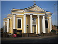
St Mary's Catholic church, Loughborough
On Ashby Road just west of the town centre.
Image: © Richard Vince
Taken: 28 Sep 2013
0.13 miles
9
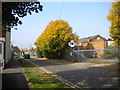
Site of Derby Road station, Loughborough
Seen from Station Avenue, this is an entrance to the site of Derby Road railway station, the London and North Western Railway's outpost in Loughborough. It was at the end of a not particularly direct branch line from Coalville, where it joined the Midland and LNWR joint line from Nuneaton. Most of the trackbed of the line through Loughborough has been converted into a footpath and cycleway, but the site of the station is largely in industrial use. The peaked roof visible on the right is that of the former goods shed.
Image: © Richard Vince
Taken: 28 Sep 2013
0.13 miles
10

Benchmark on #148 Ashby Road
Ordnance Survey cut mark benchmark described on the Bench Mark Database at http://www.bench-marks.org.uk/bm66883
Image: © Roger Templeman
Taken: 20 May 2015
0.14 miles