IMAGES TAKEN NEAR TO
Foxcote Drive, LOUGHBOROUGH, LE11 4WF
Introduction
This page details the photographs taken nearby to Foxcote Drive, LE11 4WF by members of the Geograph project.
The Geograph project started in 2005 with the aim of publishing, organising and preserving representative images for every square kilometre of Great Britain, Ireland and the Isle of Man.

There are currently over 7.5m images from over14,400 individuals and you can help contribute to the project by visiting https://www.geograph.org.uk
Image Map (Loading...)


Getting Data...Please wait
Leaflet Map data © OpenStreetMap
Images are licensed for reuse under creativecommons.org/licenses/by-sa/2.0
Notes
- Clicking on the map will re-center to the selected point.
- The higher the marker number, the further away the image location is from the centre of the postcode.
Image Listing (5 Images Found)
Images are licensed for reuse under creativecommons.org/licenses/by-sa/2.0
Image
Details
Distance
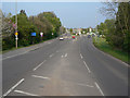
1
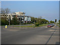
Ashby Road at Snell's Nook
The building to the left is brand new and unidentified. Current maps still show a filling station at the location.
Image: © Alan Murray-Rust
Taken: 16 Apr 2011
0.15 miles
3
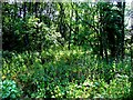
Woodland
Woodland by Snell's Nook Lane
Image: © Andrew Tatlow
Taken: 3 Jul 2006
0.21 miles
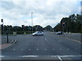
5
Ashby Road
Looking east at Snell's Nook Lodge.
Image: © Alan Murray-Rust
Taken: 16 Apr 2011
0.23 miles