IMAGES TAKEN NEAR TO
Leighton Avenue, LOUGHBOROUGH, LE11 4WE
Introduction
This page details the photographs taken nearby to Leighton Avenue, LE11 4WE by members of the Geograph project.
The Geograph project started in 2005 with the aim of publishing, organising and preserving representative images for every square kilometre of Great Britain, Ireland and the Isle of Man.

There are currently over 7.5m images from over14,400 individuals and you can help contribute to the project by visiting https://www.geograph.org.uk
Image Map (Loading...)


Getting Data...Please wait
Leaflet Map data © OpenStreetMap
Images are licensed for reuse under creativecommons.org/licenses/by-sa/2.0
Notes
- Clicking on the map will re-center to the selected point.
- The higher the marker number, the further away the image location is from the centre of the postcode.
Image Listing (22 Images Found)
Images are licensed for reuse under creativecommons.org/licenses/by-sa/2.0
Image
Details
Distance
1
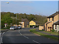
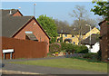
Ravensthorpe Drive
The area was one of the later developments of large scale housing in the western suburbs of Loughborough.
Image: © Alan Murray-Rust
Taken: 16 Apr 2011
0.03 miles
2
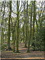
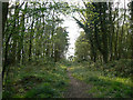
In Booth Wood
An established broadleaf wood purchased by the local authority in the 1970s and opened up for public access as well as being a wildlife reserve.
Image: © Alan Murray-Rust
Taken: 16 Apr 2011
0.07 miles
3
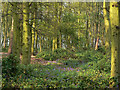
Bluebells in Booth Wood
An established broadleaf wood purchased by the local authority in the 1970s and opened up for public access as well as being a wildlife reserve.
Image: © Alan Murray-Rust
Taken: 16 Apr 2011
0.07 miles
4
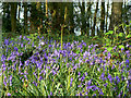
Bluebells in Booth Wood
An established broadleaf wood purchased by the local authority in the 1970s and opened up for public access as well as being a wildlife reserve.
Image: © Alan Murray-Rust
Taken: 16 Apr 2011
0.07 miles
5
Roundhill Way
The footpath represents access to Roundhill Way on foot, rather than the street itself.
Image: © Alan Murray-Rust
Taken: 16 Apr 2011
0.11 miles
6
Central ride, Booth Wood
This cuts the wood in two in a roughly east-west direction.
Image: © Alan Murray-Rust
Taken: 16 Apr 2011
0.11 miles
7
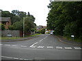
Rowbank Way, Loughborough
Off Hurstwood Road, which becomes Ravensthorpe Drive immediately to the left of here.
Image: © Richard Vince
Taken: 19 Jun 2021
0.12 miles
8
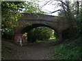
Bridge over the footpath
This imposing three-arch bridge was never more than an accommodation bridge across the railway that used to run here. It now serves as a footbridge between two parts of the adjoining housing development. The railway was the former Coalville to Loughborough branch of the London and North Western Railway.
Image: © Alan Murray-Rust
Taken: 16 Apr 2011
0.12 miles
9
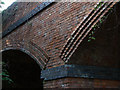
Railway bridge detail
Belonging to the bridge shown here http://www.geograph.org.uk/photo/2366753 . The brickwork is not inherently decorative, but derives from the angles of the brickwork forming the arches which are skewed to the line of the railway.
Image: © Alan Murray-Rust
Taken: 16 Apr 2011
0.12 miles
10
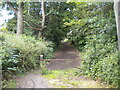
Footpath off Hurstwood Road, Loughborough (1)
Reusing the trackbed of the former London & North Western Railway branch line from Coalville to Loughborough (Derby Road), most of which in Loughborough has been converted into a footpath.
Image: © Richard Vince
Taken: 19 Jun 2021
0.12 miles