IMAGES TAKEN NEAR TO
Trelissick Close, LOUGHBOROUGH, LE11 4TZ
Introduction
This page details the photographs taken nearby to Trelissick Close, LE11 4TZ by members of the Geograph project.
The Geograph project started in 2005 with the aim of publishing, organising and preserving representative images for every square kilometre of Great Britain, Ireland and the Isle of Man.

There are currently over 7.5m images from over14,400 individuals and you can help contribute to the project by visiting https://www.geograph.org.uk
Image Map
Images are licensed for reuse under creativecommons.org/licenses/by-sa/2.0
Notes
- Clicking on the map will re-center to the selected point.
- The higher the marker number, the further away the image location is from the centre of the postcode.
Image Listing (31 Images Found)
Images are licensed for reuse under creativecommons.org/licenses/by-sa/2.0
Image
Details
Distance
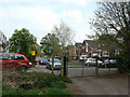
1
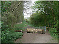
Woodland access
Despite gate and fence, there is clearly significant foot traffic through here.
Image: © Alan Murray-Rust
Taken: 16 Apr 2011
0.04 miles
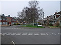
3
Gated footpath, Thorpe Acre
Not marked as a public right of way on the OS maps, this shot was taken from the public footpath heading towards Garendon Park from the end of Coe Avenue.
Image: © Richard Vince
Taken: 19 Jun 2021
0.05 miles
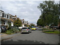
4
Road junction in Thorpe Acre, Loughborough
Cycle Route 6 goes straight ahead down Coe Avenue
Image: © Tim Heaton
Taken: 22 Mar 2012
0.05 miles
5
Gateway into Garendon Park
At the end of Coe Avenue. The signed footpath is the other side of a fence at this point, but about 20 metres to the left joins the track through the gate without any sort of barrier or sign.
Image: © Alan Murray-Rust
Taken: 16 Apr 2011
0.06 miles
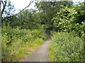
6
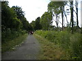
Public footpath towards Garendon Park, Thorpe Acre
So well used for family recreation that I was unable to get a shot that didn't contain humans. The houses on the right are on Lilleshall Way and St Olaves Close.
Image: © Richard Vince
Taken: 19 Jun 2021
0.07 miles
7
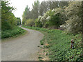
Back Lane, Garendon Park
Even looking at old maps it is not clear whether this was a public lane or an estate track. Today it is a public footpath and cycleway, forming part of Sustrans route 6.
Image: © Alan Murray-Rust
Taken: 16 Apr 2011
0.07 miles
8
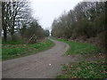
National Cycle Route 6 leaving Loughborough
The lane, an extension of Coe avenue, runs along the boundary of Garendon Park
Image: © Tim Heaton
Taken: 22 Mar 2012
0.10 miles
9
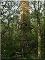
Garendon Obelisk
Placed where it would have been conspicuous from Garendon Hall, it is now closely beset by woodland, and in a relatively poor state. Built around 1730 and originally covered with stucco, most of this has flaked away leaving the original brickwork exposed. The main pedestal below the balls supporting the main needle has been completely rebuilt using modern breeze block. Listed Grade II, the listing refers to a stone pedestal.
Image: © Alan Murray-Rust
Taken: 16 Apr 2011
0.14 miles
10
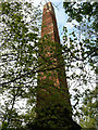
Garendon Obelisk
Looking up at the needle showing bits of the decayed stucco. The Obelisk is so hemmed in with trees that a complete view of it is impossible. See http://www.geograph.org.uk/photo/2364470 for more details.
Image: © Alan Murray-Rust
Taken: 16 Apr 2011
0.14 miles