IMAGES TAKEN NEAR TO
Cleeve Mount, LOUGHBOROUGH, LE11 4SD
Introduction
This page details the photographs taken nearby to Cleeve Mount, LE11 4SD by members of the Geograph project.
The Geograph project started in 2005 with the aim of publishing, organising and preserving representative images for every square kilometre of Great Britain, Ireland and the Isle of Man.

There are currently over 7.5m images from over14,400 individuals and you can help contribute to the project by visiting https://www.geograph.org.uk
Image Map
Images are licensed for reuse under creativecommons.org/licenses/by-sa/2.0
Notes
- Clicking on the map will re-center to the selected point.
- The higher the marker number, the further away the image location is from the centre of the postcode.
Image Listing (25 Images Found)
Images are licensed for reuse under creativecommons.org/licenses/by-sa/2.0
Image
Details
Distance
1
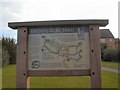
Thorpe Acre Trail
Map and information board at Kenilworth Avenue on the Thorpe Acre Trail.
Image: © Gerald England
Taken: Unknown
0.12 miles
2
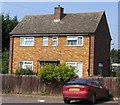
On-site house
This house is on the Burleigh Community College Site.
Image: © Andrew Tatlow
Taken: 3 Jul 2006
0.13 miles
4
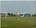
College playing fields
At the back of Burleigh Community College and Garendon High School. In the distance one of the distinctive residential towers at Loughborough University.
Image: © Alan Murray-Rust
Taken: 16 Apr 2011
0.14 miles
5
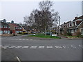
Road junction in Thorpe Acre, Loughborough
Cycle Route 6 goes straight ahead down Coe Avenue
Image: © Tim Heaton
Taken: 22 Mar 2012
0.18 miles
6
Bus Bays on Thorpe Hill
With 3 large schools on either side of this road there has to be space for the school buses.
Image: © Andrew Tatlow
Taken: 3 Jul 2006
0.18 miles
7
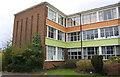
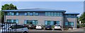
South wing of Charnwood College, Thorpe Hill
There is an OS benchmark Image on the near corner, left hand face, of the wing
Image: © Roger Templeman
Taken: 8 Apr 2016
0.18 miles
8
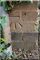
Benchmark on Charnwood College
Ordnance Survey cut mark benchmark described on the Bench Mark Database at http://www.bench-marks.org.uk/bm74764
Image: © Roger Templeman
Taken: 8 Apr 2016
0.18 miles
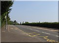
9
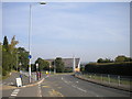
Thorpe Hill, Loughborough
Thorpe Hill (foreground) actually continues as the side road on the left just beyond the "Keep Clear" markings; at that point the main road becomes Alan Moss Road, and passes the Loughborough Church of Jesus Christ of Latter Day Saints. The entrance in the left foreground provides access to Garendon High School.
Image: © Richard Vince
Taken: 28 Sep 2013
0.19 miles
10
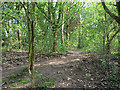
Woodland footpath
In a belt of woodland that would originally have formed the boundary of Garendon Park. The path leads through to Booth Wood. The latter is owned by Charnwood Borough Council and is publicly accessible. As far as I can tell, this path is on what is still private land, although it is readily accessible and clearly heavily used.
Image: © Alan Murray-Rust
Taken: 16 Apr 2011
0.20 miles