IMAGES TAKEN NEAR TO
Gracedieu Road, LOUGHBOROUGH, LE11 4QF
Introduction
This page details the photographs taken nearby to Gracedieu Road, LE11 4QF by members of the Geograph project.
The Geograph project started in 2005 with the aim of publishing, organising and preserving representative images for every square kilometre of Great Britain, Ireland and the Isle of Man.

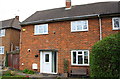
There are currently over 7.5m images from over14,400 individuals and you can help contribute to the project by visiting https://www.geograph.org.uk
Image Map
Images are licensed for reuse under creativecommons.org/licenses/by-sa/2.0
Notes
- Clicking on the map will re-center to the selected point.
- The higher the marker number, the further away the image location is from the centre of the postcode.
Image Listing (25 Images Found)
Images are licensed for reuse under creativecommons.org/licenses/by-sa/2.0
Image
Details
Distance
1
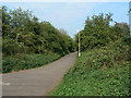
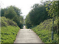
Footpath on the old railway
Much of the old London and North Western Railway branch from Coalville to Loughborough within the Loughborough area has been converted to a cycle and walkway, although it does not have formal right of way designation.
Image: © Alan Murray-Rust
Taken: 16 Apr 2011
0.04 miles
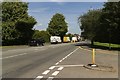
2
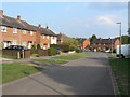
Gracedieu Road
This is a side-section of the road, the main part of which runs across the end of the picture.
Image: © Alan Murray-Rust
Taken: 16 Apr 2011
0.04 miles
3
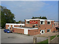
The Garendon
Function suite in the western suburbs of Loughborough.
Image: © Alan Murray-Rust
Taken: 16 Apr 2011
0.09 miles
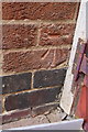
4
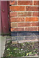
Benchmark on #359 New Ashby Road
Ordnance Survey cut mark benchmark described on the Bench Mark Database at http://www.bench-marks.org.uk/bm74827
Image: © Roger Templeman
Taken: 8 Apr 2016
0.11 miles
5
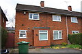
#359 New Ashby Road
There is an OS benchmark Image on the front left hand corner of the house next to the wooden gate
Image: © Roger Templeman
Taken: 8 Apr 2016
0.11 miles
6
Thorpe Hill
The scene of much building about 50 years ago.
Image: © Andrew Tatlow
Taken: 3 Jul 2006
0.12 miles
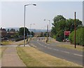
7
A512 Ashby Road
The queue of traffic is due to roadworks ahead.
Image: © Mark Anderson
Taken: 24 Jul 2019
0.12 miles
8
Benchmark on #31 Schofield Road
Ordnance Survey cut mark benchmark described on the Bench Mark Database at http://www.bench-marks.org.uk/bm74767
Image: © Roger Templeman
Taken: 8 Apr 2016
0.14 miles
9
#31 Schofield Road
There is an OS benchmark Image on the left hand side of the house inside the lean-to
Image: © Roger Templeman
Taken: 8 Apr 2016
0.14 miles
10
Footpath on the old railway
Much of the old London and North Western Railway branch from Coalville to Loughborough within the Loughborough area has been converted to a cycle and walkway, although it does not have formal right of way designation.
Image: © Alan Murray-Rust
Taken: 16 Apr 2011
0.18 miles