IMAGES TAKEN NEAR TO
Gisborough Way, LOUGHBOROUGH, LE11 4FU
Introduction
This page details the photographs taken nearby to Gisborough Way, LE11 4FU by members of the Geograph project.
The Geograph project started in 2005 with the aim of publishing, organising and preserving representative images for every square kilometre of Great Britain, Ireland and the Isle of Man.

There are currently over 7.5m images from over14,400 individuals and you can help contribute to the project by visiting https://www.geograph.org.uk
Image Map
Images are licensed for reuse under creativecommons.org/licenses/by-sa/2.0
Notes
- Clicking on the map will re-center to the selected point.
- The higher the marker number, the further away the image location is from the centre of the postcode.
Image Listing (26 Images Found)
Images are licensed for reuse under creativecommons.org/licenses/by-sa/2.0
Image
Details
Distance
1
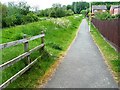
Back Lane
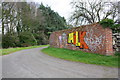
Even looking at old maps it is not clear whether this was a public lane or an estate track. It runs along the northern boundary of Garendon Park and comes to a more or less dead end where it hits modern housing development at Coe Avenue. Today it is a public footpath and cycleway, forming part of Sustrans route 6.
Image: © Alan Murray-Rust
Taken: 16 Apr 2011
0.07 miles
2
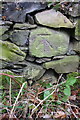
Garendon Park northeastern boundary wall
There is an OS benchmark Image on a square stone in the wall near the left hand edge of the image
Image: © Roger Templeman
Taken: 8 Apr 2016
0.09 miles
3
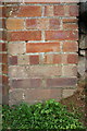
Benchmark on Garendon Park boundary wall
Ordnance Survey cut mark benchmark described on the Bench Mark Database at http://www.bench-marks.org.uk/bm74741
Image: © Roger Templeman
Taken: 8 Apr 2016
0.11 miles
4
Brick wall at junction of footpaths
There is an OS benchmark Image at the right hand edge of the small section of wall right of the right hand wall corner
Image: © Roger Templeman
Taken: 8 Apr 2016
0.11 miles
5
Benchmark on wall at footpath junction
Ordnance Survey cut mark benchmark described on the Bench Mark Database at http://www.bench-marks.org.uk/bm74739
Image: © Roger Templeman
Taken: 8 Apr 2016
0.12 miles
6
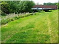
Road bridge over Black Brook Loughborough
Image: © Andy Jamieson
Taken: 26 May 2009
0.12 miles
7
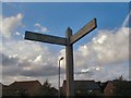
Poetic Sign
This signpost at Stonebow Washlands on the Thorpe Acre Trail was erected in 2000 and has poetry (by Lewis Carroll) on its arms:
"Will you walk a
little faster?"
said a whiting to a snail
Image: © Gerald England
Taken: Unknown
0.12 miles
8
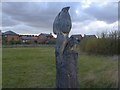
Kingfisher Totem Pole
This sculpture by Martin Heron was erected by the Thorpe Acre Trail as part of a Millennium Trail in the area known as Stonebow Washlands.
Image: © Gerald England
Taken: Unknown
0.12 miles