IMAGES TAKEN NEAR TO
Rivington Drive, LOUGHBOROUGH, LE11 4EJ
Introduction
This page details the photographs taken nearby to Rivington Drive, LE11 4EJ by members of the Geograph project.
The Geograph project started in 2005 with the aim of publishing, organising and preserving representative images for every square kilometre of Great Britain, Ireland and the Isle of Man.

There are currently over 7.5m images from over14,400 individuals and you can help contribute to the project by visiting https://www.geograph.org.uk
Image Map (Loading...)


Getting Data...Please wait
Leaflet Map data © OpenStreetMap
Images are licensed for reuse under creativecommons.org/licenses/by-sa/2.0
Notes
- Clicking on the map will re-center to the selected point.
- The higher the marker number, the further away the image location is from the centre of the postcode.
Image Listing (28 Images Found)
Images are licensed for reuse under creativecommons.org/licenses/by-sa/2.0
Image
Details
Distance
1
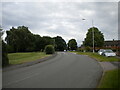
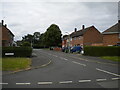
Old Ashby Road, Loughborough (2)
Approaching the junction with Hermitage Road.
Image: © Richard Vince
Taken: 19 Jun 2021
0.05 miles
2
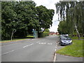
Old Ashby Road, Loughborough (1)
Looking towards the town centre from its junction with Windleden Road.
Image: © Richard Vince
Taken: 19 Jun 2021
0.05 miles
3
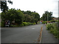
Windleden Road, Loughborough
At its junction with De Lisle Court (left).
Image: © Richard Vince
Taken: 19 Jun 2021
0.05 miles
4
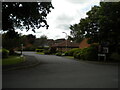
De Lisle Court, Loughborough
A short cul de sac off Windleden Road.
Image: © Richard Vince
Taken: 19 Jun 2021
0.06 miles
5
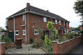
Nos. 105 and 103 Hermitage Road
There is an OS benchmark Image on the near corner, left hand face, of house pair
Image: © Roger Templeman
Taken: 1 Oct 2016
0.07 miles
6
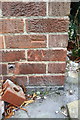
Benchmark on #105 Hermitage Road
Ordnance Survey cut mark benchmark described on the Bench Mark Database at http://www.bench-marks.org.uk/bm79391
Image: © Roger Templeman
Taken: 1 Oct 2016
0.07 miles
7
Hermitage Road, Loughborough (2)
The short section linking to Old Ashby Road, seen from the main part of Hermitage Road.
Image: © Richard Vince
Taken: 19 Jun 2021
0.09 miles
8
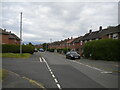
Hermitage Road, Loughborough (1)
The main part of the road, seen at its junction with the part linking it to Old Ashby Road (left).
Image: © Richard Vince
Taken: 19 Jun 2021
0.10 miles
9
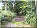
Footpath off Hurstwood Road, Loughborough (1)
Reusing the trackbed of the former London & North Western Railway branch line from Coalville to Loughborough (Derby Road), most of which in Loughborough has been converted into a footpath.
Image: © Richard Vince
Taken: 19 Jun 2021
0.13 miles
10
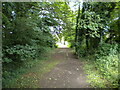
Footpath off Hurstwood Road, Loughborough (2)
Reusing the trackbed of the former London & North Western Railway branch line from Coalville to Loughborough (Derby Road), most of which in Loughborough has been converted into a footpath.
Image: © Richard Vince
Taken: 19 Jun 2021
0.13 miles