IMAGES TAKEN NEAR TO
LOUGHBOROUGH, LE11 3UE
Introduction
This page details the photographs taken nearby to LE11 3UE by members of the Geograph project.
The Geograph project started in 2005 with the aim of publishing, organising and preserving representative images for every square kilometre of Great Britain, Ireland and the Isle of Man.

There are currently over 7.5m images from over14,400 individuals and you can help contribute to the project by visiting https://www.geograph.org.uk
Image Map (Loading...)


Getting Data...Please wait
Leaflet Map data © OpenStreetMap
Images are licensed for reuse under creativecommons.org/licenses/by-sa/2.0
Notes
- Clicking on the map will re-center to the selected point.
- The higher the marker number, the further away the image location is from the centre of the postcode.
Image Listing (14 Images Found)
Images are licensed for reuse under creativecommons.org/licenses/by-sa/2.0
Image
Details
Distance
1
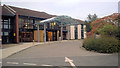
Burleigh Court, Loughborough
4 Star hotel on the Loughborough University campus http://www.burleigh-court.co.uk/
Image: © Paul Gillett
Taken: 6 Oct 2017
0.10 miles
2
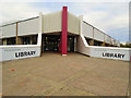
Pilkington Library Loughborough University
The Pilkington Library opened in 1980. It covers 9,161 square metres over four floors with 1375 study places (up from 780 prior to the renovation in late 2013). The Library has a history of undertaking research in the field of library and information work
http://www.lboro.ac.uk/library/
Image: © Paul Gillett
Taken: 20 Oct 2018
0.10 miles
3
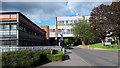
University Road, Loughborough University
Image: © David Martin
Taken: 1 Jul 2019
0.13 miles
4
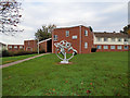
Macaroni Constellation sculpture
On the campus of Loughborough University, part of a sculpture trail http://www.arts.lboro.ac.uk/collection/campus_art_trail/
Image: © Paul Gillett
Taken: 20 Oct 2018
0.15 miles
5
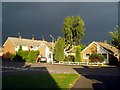
Holywell Drive, Loughborough, before a hailstorm
The road on the left is Coniston Crescent; nos. 87 and 89 Holywell Drive are behind me.
Image: © Alex Cameron
Taken: 7 Jul 2005
0.18 miles
6
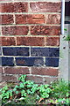
Benchmark on #433 New Ashby Road
Ordnance Survey cut mark benchmark described on the Bench Mark Database at http://www.bench-marks.org.uk/bm79498
Image: © Roger Templeman
Taken: 1 Oct 2016
0.20 miles
7
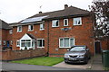
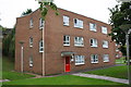
Nos. 433 and 435 New Ashby Road
There is an OS benchmark Image on the front of the right hand house at its right hand corner
Image: © Roger Templeman
Taken: 1 Oct 2016
0.20 miles
10

Benchmark on #483 New Ashby Road
Ordnance Survey cut mark benchmark described on the Bench Mark Database at http://www.bench-marks.org.uk/bm79392
Image: © Roger Templeman
Taken: 1 Oct 2016
0.21 miles