IMAGES TAKEN NEAR TO
Kingfisher Way, LOUGHBOROUGH, LE11 3FA
Introduction
This page details the photographs taken nearby to Kingfisher Way, LE11 3FA by members of the Geograph project.
The Geograph project started in 2005 with the aim of publishing, organising and preserving representative images for every square kilometre of Great Britain, Ireland and the Isle of Man.

There are currently over 7.5m images from over14,400 individuals and you can help contribute to the project by visiting https://www.geograph.org.uk
Image Map
Images are licensed for reuse under creativecommons.org/licenses/by-sa/2.0
Notes
- Clicking on the map will re-center to the selected point.
- The higher the marker number, the further away the image location is from the centre of the postcode.
Image Listing (29 Images Found)
Images are licensed for reuse under creativecommons.org/licenses/by-sa/2.0
Image
Details
Distance
1

Loughborough, Leics
A privately owned pond known locally as "Swan Lake" situated alongside a public footpath that links Ingle Pingle Lane and Goldfinch Close (in the vicinity of premises belonging to the University of Loughborough).
Image: © David Hallam-Jones
Taken: 7 Jul 2012
0.09 miles
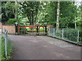
2
Loughborough, Leics
A glimpse of a privately owned pond known locally as "Swan Lake" can be seen here through the gate at the side of a public footpath linking Ingle Pingle Lane and Goldfinch Close (in the vicinity of premises belonging to the University of Loughborough).
Image: © David Hallam-Jones
Taken: 7 Jul 2012
0.09 miles
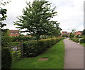
3
Loughborough, Leics
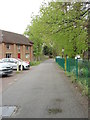
The gates of Ingle Pingle House on Ingle Pingle Lane, a lane that leads to the nearby Loughborough Lawn Tennis Club. The 'big house' situated in the grounds beyond the gates (but not visible in this picture) is a fairly modern property owned by a local building construction company director. The phrase Ingle Pingle is apparently a combination of Norse and medieval English. Ingle, is a Norse word meaning pasture land and Pingle is a medieval English word for a small piece of land.
Image: © David Hallam-Jones
Taken: 7 Jul 2012
0.14 miles
4
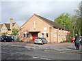
Emmanuel Church Hall - Forest Road
Image: © Betty Longbottom
Taken: 10 May 2012
0.14 miles
6

Loughborough, Leics
A view of Emmanuel Anglican Church (1835), a modern extension plus its grounds, with Forest Road B5350 running alongside in the direction of Loughborough town centre. This is one of the two Anglican churches in Loughborough.
Image: © David Hallam-Jones
Taken: 7 Jul 2012
0.16 miles
7
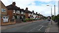
Colgrove Road
Housing typical of this part of Loughborough.
Image: © Peter Mackenzie
Taken: 3 Jul 2017
0.17 miles
8
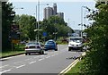
Epinal Way in Loughborough
Looking towards the Towers Halls of Residence, 210ft tall and 22 storeys.
Image: © Mat Fascione
Taken: 20 Jun 2010
0.17 miles
9

Loughborough, Leics (Leisure Centre)
At this point in a stroll from Ingle Pingle Lane towards Loughborough Leisure Centre (seen beyond the parked cars), a footbridge carries pedestrian traffic and cyclists across Wood Brook here.
Image: © David Hallam-Jones
Taken: 7 Jul 2012
0.18 miles