IMAGES TAKEN NEAR TO
Chester Close, LOUGHBOROUGH, LE11 3BD
Introduction
This page details the photographs taken nearby to Chester Close, LE11 3BD by members of the Geograph project.
The Geograph project started in 2005 with the aim of publishing, organising and preserving representative images for every square kilometre of Great Britain, Ireland and the Isle of Man.

There are currently over 7.5m images from over14,400 individuals and you can help contribute to the project by visiting https://www.geograph.org.uk
Image Map
Images are licensed for reuse under creativecommons.org/licenses/by-sa/2.0
Notes
- Clicking on the map will re-center to the selected point.
- The higher the marker number, the further away the image location is from the centre of the postcode.
Image Listing (102 Images Found)
Images are licensed for reuse under creativecommons.org/licenses/by-sa/2.0
Image
Details
Distance
1
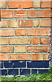
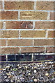
Benchmark on #97 William Street
Ordnance Survey cut mark benchmark described on the Bench Mark Database at http://www.bench-marks.org.uk/bm66881
Image: © Roger Templeman
Taken: 20 May 2015
0.07 miles
2
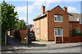
#97 William Street at junction with True Lovers Lane
There is an OS benchmark Image on the side of the house near its front corner
Image: © Roger Templeman
Taken: 20 May 2015
0.07 miles
3
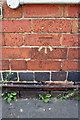
Benchmark on #36 York Road
Ordnance Survey cut mark benchmark described on the Bench Mark Database at http://www.bench-marks.org.uk/bm66882
Image: © Roger Templeman
Taken: 20 May 2015
0.09 miles
4

#36 York Road
There is an OS benchmark Image on the right hand side of the house near its front corner
Image: © Roger Templeman
Taken: 20 May 2015
0.09 miles
5
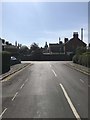
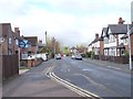
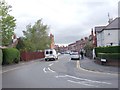
View from Burleigh Road, Loughborough
Image: © Dave Thompson
Taken: 20 May 2020
0.14 miles
6
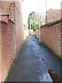
True Lovers Walk - Frederick Street
Image: © Betty Longbottom
Taken: 10 May 2012
0.15 miles
7
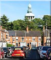
Arthur Street in Loughborough
The top of the Loughborough Carillon in Queen's Park is visible beyond the houses.
Image: © Mat Fascione
Taken: 23 May 2019
0.15 miles
8
Frederick Street - viewed from Browns Lane
Image: © Betty Longbottom
Taken: 10 May 2012
0.15 miles
9
Benchmark on Loughborough College 2012 Centre
Ordnance Survey cut mark benchmark described on the Bench Mark Database at http://www.bench-marks.org.uk/bm66876
Image: © Roger Templeman
Taken: 20 May 2015
0.16 miles
10
Frederick Street - viewed from Browns Lane
Image: © Betty Longbottom
Taken: 10 May 2012
0.16 miles