IMAGES TAKEN NEAR TO
Shelthorpe Road, LOUGHBOROUGH, LE11 2PF
Introduction
This page details the photographs taken nearby to Shelthorpe Road, LE11 2PF by members of the Geograph project.
The Geograph project started in 2005 with the aim of publishing, organising and preserving representative images for every square kilometre of Great Britain, Ireland and the Isle of Man.

There are currently over 7.5m images from over14,400 individuals and you can help contribute to the project by visiting https://www.geograph.org.uk
Image Map (Loading...)


Getting Data...Please wait
Leaflet Map data © OpenStreetMap
Images are licensed for reuse under creativecommons.org/licenses/by-sa/2.0
Notes
- Clicking on the map will re-center to the selected point.
- The higher the marker number, the further away the image location is from the centre of the postcode.
Image Listing (28 Images Found)
Images are licensed for reuse under creativecommons.org/licenses/by-sa/2.0
Image
Details
Distance
1
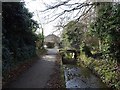
Footpath by Grammar School Brook
The little bridge leads to some waste ground that used to be allotments.
Image: © Ian Calderwood
Taken: 26 Jan 2018
0.06 miles
2
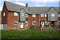
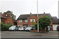
Houses at Skelthorpe Road / Castledine Street Extension junction
There is an OS benchmark Image on the front of the left hand house at its left hand corner
Image: © Roger Templeman
Taken: 30 Sep 2015
0.07 miles
3
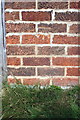
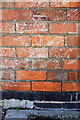
Benchmark on #70 Skelthorpe Road
Ordnance Survey cut mark benchmark described on the Bench Mark Database at http://www.bench-marks.org.uk/bm70594
Image: © Roger Templeman
Taken: 30 Sep 2015
0.08 miles
4
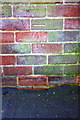
Benchmark on #149 Leicester Road
Ordnance Survey cut mark benchmark described on the Bench Mark Database at http://www.bench-marks.org.uk/bm63460
Image: © Roger Templeman
Taken: 5 Jan 2015
0.11 miles
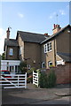
5

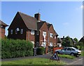
Houses at Leicester Road / Shelthorpe Road junction
There is an OS benchmark Image on the corner of the house to the right of the wooden gate
Image: © Roger Templeman
Taken: 5 Jan 2015
0.11 miles
7
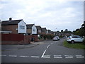
Houses on Shelthorpe Road
Notice that the English flag is displayed prominently. Something to do with football?
Image: © Andrew Tatlow
Taken: 17 Jun 2006
0.17 miles
8
Service road off Whaddon Drive, Leicester
This service road provides access to houses parallel to Leicester Road, and can be reached from Whaddon Drive (foreground). Unfortunately, some people seem to have decided that the grassed area between the service road and Leicester Road (right) is a car park.
Image: © Richard Vince
Taken: 13 Sep 2014
0.18 miles
9
Benchmark on #62 Castledine Street
Ordnance Survey cut mark benchmark described on the Bench Mark Database at http://www.bench-marks.org.uk/bm70595
Image: © Roger Templeman
Taken: 30 Sep 2015
0.18 miles
10
#62 Castledine Street, 'Whitegates'
There is an OS benchmark Image on the boundary wall at its junction with the house.
Image: © Roger Templeman
Taken: 30 Sep 2015
0.18 miles