IMAGES TAKEN NEAR TO
Lace Avenue, LOUGHBOROUGH, LE11 2FE
Introduction
This page details the photographs taken nearby to Lace Avenue, LE11 2FE by members of the Geograph project.
The Geograph project started in 2005 with the aim of publishing, organising and preserving representative images for every square kilometre of Great Britain, Ireland and the Isle of Man.

There are currently over 7.5m images from over14,400 individuals and you can help contribute to the project by visiting https://www.geograph.org.uk
Image Map
Images are licensed for reuse under creativecommons.org/licenses/by-sa/2.0
Notes
- Clicking on the map will re-center to the selected point.
- The higher the marker number, the further away the image location is from the centre of the postcode.
Image Listing (13 Images Found)
Images are licensed for reuse under creativecommons.org/licenses/by-sa/2.0
Image
Details
Distance
1
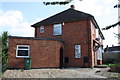
Outbuilding and house at #104 Manor Road
There is an OS benchmark Image on the outbuilding wall left of the junction with the archway wall
Image: © Roger Templeman
Taken: 30 Sep 2015
0.14 miles
2
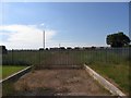
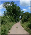
End of the world
This is the end of Shelthorpe, a large council housing estate. There's another world out there somewhere Image
Image: © Andrew Tatlow
Taken: 17 Jun 2006
0.14 miles
3
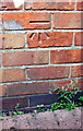
Benchmark on outbuilding at #91 Manor Road
Ordnance Survey cut mark benchmark described on the Bench Mark Database at http://www.bench-marks.org.uk/bm70598
Image: © Roger Templeman
Taken: 30 Sep 2015
0.14 miles
4
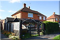
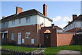
#91 Manor Road with outbuilding
There is an OS benchmark Image on the brick outbuilding (at the left hand side of the image)
Image: © Roger Templeman
Taken: 30 Sep 2015
0.14 miles
5
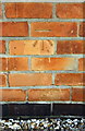
Benchmark on outbuilding of #104 Manor Road
Ordnance Survey cut mark benchmark described on the Bench Mark Database at http://www.bench-marks.org.uk/bm70599
Image: © Roger Templeman
Taken: 30 Sep 2015
0.14 miles
7
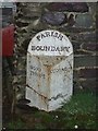
Old Boundary Marker
Parish Boundary Marker on east side of road beside the entrance to Renals Farm, Woodthorpe. This was formerly on the boundary between Woodthorpe and Quorndon parishes, but is now entirely in Loughborough. It may also have been moved as old OS maps do not show a parish boundary here. WOOD / THORPE and QUORNDON on its adjacent faces and PARISH / BOUNDARY at its top all in raised lettering.
Milestone Society National ID: LE_LOUG01pb
Image: © L Dyer
Taken: 7 May 2019
0.19 miles
10
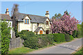
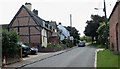
Houses in Woodthorpe
Minor road in Woodthorpe.
Image: © Wayland Smith
Taken: 22 Apr 2019
0.21 miles