Old Boundary Marker
Introduction
The photograph on this page of Old Boundary Marker by L Dyer as part of the Geograph project.
The Geograph project started in 2005 with the aim of publishing, organising and preserving representative images for every square kilometre of Great Britain, Ireland and the Isle of Man.

There are currently over 7.5m images from over 14,400 individuals and you can help contribute to the project by visiting https://www.geograph.org.uk
Old Boundary Marker
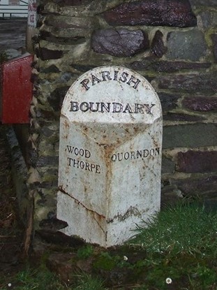
Image: © L Dyer Taken: 7 May 2019
Parish Boundary Marker on east side of road beside the entrance to Renals Farm, Woodthorpe. This was formerly on the boundary between Woodthorpe and Quorndon parishes, but is now entirely in Loughborough. It may also have been moved as old OS maps do not show a parish boundary here. WOOD / THORPE and QUORNDON on its adjacent faces and PARISH / BOUNDARY at its top all in raised lettering. Milestone Society National ID: LE_LOUG01pb
Images are licensed for reuse under creativecommons.org/licenses/by-sa/2.0
Image Location
Latitude
52.750704
Longitude
-1.196863