IMAGES TAKEN NEAR TO
Burton Walks, LOUGHBOROUGH, LE11 2DU
Introduction
This page details the photographs taken nearby to Burton Walks, LE11 2DU by members of the Geograph project.
The Geograph project started in 2005 with the aim of publishing, organising and preserving representative images for every square kilometre of Great Britain, Ireland and the Isle of Man.

There are currently over 7.5m images from over14,400 individuals and you can help contribute to the project by visiting https://www.geograph.org.uk
Image Map (Loading...)


Getting Data...Please wait
Leaflet Map data © OpenStreetMap
Images are licensed for reuse under creativecommons.org/licenses/by-sa/2.0
Notes
- Clicking on the map will re-center to the selected point.
- The higher the marker number, the further away the image location is from the centre of the postcode.
Image Listing (37 Images Found)
Images are licensed for reuse under creativecommons.org/licenses/by-sa/2.0
Image
Details
Distance
2
Benchmark on Loughborough High School, Burton Walks
Ordnance Survey cut mark benchmark described on the Bench Mark Database at http://www.bench-marks.org.uk/bm63662
Image: © Roger Templeman
Taken: 5 Jan 2015
0.07 miles
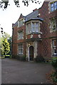
3
Loughborough High School
There is an OS benchmark Image on the corner of the building jut left of the white door
Image: © Roger Templeman
Taken: 5 Jan 2015
0.08 miles
4
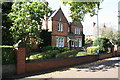
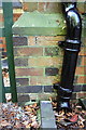
Loughborough Grammar School boarding house
There is an OS benchmark Image on the front of the building at the far corner, beside the black downpipe
Image: © Roger Templeman
Taken: 30 Sep 2015
0.08 miles
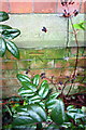
5
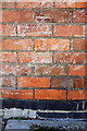
Benchmark on Loughborough Grammar School building
Ordnance Survey cut mark benchmark described on the Bench Mark Database at http://www.bench-marks.org.uk/bm70593
Image: © Roger Templeman
Taken: 30 Sep 2015
0.09 miles
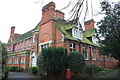
6
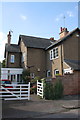
#62 Castledine Street, 'Whitegates'
There is an OS benchmark Image on the boundary wall at its junction with the house.
Image: © Roger Templeman
Taken: 30 Sep 2015
0.10 miles
7
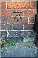
Benchmark on #62 Castledine Street
Ordnance Survey cut mark benchmark described on the Bench Mark Database at http://www.bench-marks.org.uk/bm70595
Image: © Roger Templeman
Taken: 30 Sep 2015
0.10 miles
8
Benchmark on #8A Park Street
Ordnance Survey cut mark benchmark described on the Bench Mark Database at http://www.bench-marks.org.uk/bm70592
Image: © Roger Templeman
Taken: 30 Sep 2015
0.13 miles
9
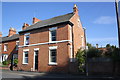
#9 Park Street
There is an OS benchmark Image on the front of the house at the right hand corner
Image: © Roger Templeman
Taken: 30 Sep 2015
0.13 miles
10
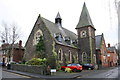
Former church at Princess Street / Victoria Street junction
The 19th century listed building, once the Unitarian Church was converted and modernised in the early 1990s and is now occupied by Mind & Body Integrated Therapies. There is an OS benchmark Image on the end of the wall at the junction left of the street name sign
Image: © Roger Templeman
Taken: 5 Jan 2015
0.14 miles