IMAGES TAKEN NEAR TO
LOUGHBOROUGH, LE11 1YX
Introduction
This page details the photographs taken nearby to LE11 1YX by members of the Geograph project.
The Geograph project started in 2005 with the aim of publishing, organising and preserving representative images for every square kilometre of Great Britain, Ireland and the Isle of Man.

There are currently over 7.5m images from over14,400 individuals and you can help contribute to the project by visiting https://www.geograph.org.uk
Image Map (Loading...)


Getting Data...Please wait
Leaflet Map data © OpenStreetMap
Images are licensed for reuse under creativecommons.org/licenses/by-sa/2.0
Notes
- Clicking on the map will re-center to the selected point.
- The higher the marker number, the further away the image location is from the centre of the postcode.
Image Listing (335 Images Found)
Images are licensed for reuse under creativecommons.org/licenses/by-sa/2.0
Image
Details
Distance
1
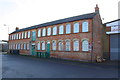
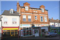
Factory on Barrack Row
There is an OS benchmark Image on the front of the building left of the downpipe on the right hand corner
Image: © Roger Templeman
Taken: 5 Jan 2015
0.01 miles
2
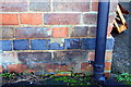
Benchmark on factory on Barrack Row
Ordnance Survey cut mark benchmark described on the Bench Mark Database at http://www.bench-marks.org.uk/bm63426
Image: © Roger Templeman
Taken: 5 Jan 2015
0.01 miles
3
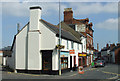
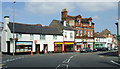
Nottingham Road
Note "The Stag & Pheasant Home Ales" ghost sign on the brick gable.
Image: © Thomas Nugent
Taken: 8 Sep 2014
0.03 miles
4
Benchmark on #24 Nottingham Road
Ordnance Survey cut mark benchmark described on the Bench Mark Database at http://www.bench-marks.org.uk/bm63444
Image: © Roger Templeman
Taken: 5 Jan 2015
0.03 miles
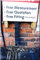
5
Shops on Nottingham Road
There is an OS benchmark Image at the left hand end of the Universal flooring shop under advertising signs attached to a downpipe
Image: © Roger Templeman
Taken: 5 Jan 2015
0.03 miles
6
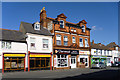
Former pub, Nottingham Road
The stonework above the main door bears the date 1887. Painted on the wall at the top is what looks like ' The Stag & Pheasant Home Ales'.
Image: © Robin Webster
Taken: 25 Mar 2016
0.03 miles
7
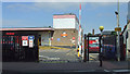
Royal Mail depot, Loughborough
The Nottingham Road side of the depot.
Image: © Thomas Nugent
Taken: 8 Sep 2014
0.03 miles
8
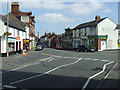
Nottingham Road
Nottingham Road is in the foreground and continuing to the left after the Give Way line. Cradock Street is on the right.
Image: © Thomas Nugent
Taken: 8 Sep 2014
0.03 miles

10
Nottingham Road
Cradock Street is on the right.
Image: © Thomas Nugent
Taken: 8 Sep 2014
0.04 miles