IMAGES TAKEN NEAR TO
Pinfold Gate, LOUGHBOROUGH, LE11 1DQ
Introduction
This page details the photographs taken nearby to Pinfold Gate, LE11 1DQ by members of the Geograph project.
The Geograph project started in 2005 with the aim of publishing, organising and preserving representative images for every square kilometre of Great Britain, Ireland and the Isle of Man.

There are currently over 7.5m images from over14,400 individuals and you can help contribute to the project by visiting https://www.geograph.org.uk
Image Map (Loading...)


Getting Data...Please wait
Leaflet Map data © OpenStreetMap
Images are licensed for reuse under creativecommons.org/licenses/by-sa/2.0
Notes
- Clicking on the map will re-center to the selected point.
- The higher the marker number, the further away the image location is from the centre of the postcode.
Image Listing (363 Images Found)
Images are licensed for reuse under creativecommons.org/licenses/by-sa/2.0
Image
Details
Distance
1
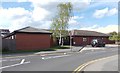
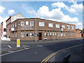
Pinfold Medical Practice - Pinfold Gate
Image: © Betty Longbottom
Taken: 8 May 2012
0.02 miles
2
Pinfoldgate, Loughborough, Leics
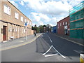
This is the mid-point (approximately) of Pinfoldgate, with the north-easterly half of it now on the other side of the 'new' inner relief road (the A6/Jubilee Way) seen ahead hosting one end of the new Court Building (opened in 2008). On this side of the ornamental arch/gateway, on the left, is the corner of a building occupied by a G.P. surgery.
Image: © David Hallam-Jones
Taken: 9 Nov 2014
0.02 miles
3
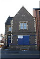
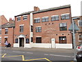
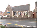
#25 Pinfold Gate
Former Warner Street School & Schoolhouse
Image: © Roger Templeman
Taken: 30 Sep 2015
0.03 miles
4
Midlands Co-operative Funeral Service - Aumberry Gap
Image: © Betty Longbottom
Taken: 8 May 2012
0.03 miles
5

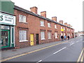
Pinfoldgate, Loughborough, Leics
A row of Grade II-listed early-to-mid C19th cottages at the north-easterly end of Pinfoldgate and a basket-handle archway leading to the rear of them. These may have been built for the families of woollen stocking industry workers in local factories? Ahead are High Street and Leicester Road that meet at this junction. The words Pinfold gata (Scandinavian for street) suggest that this was the street that led to the pinfold that was set aside for wandering, unclaimed animals.
Image: © David Hallam-Jones
Taken: 9 Nov 2014
0.03 miles
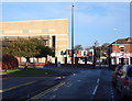
8
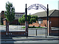
Pinfold Gate
The road is bisected by the new A6 Jubilee Way at this point.
Image: © Thomas Nugent
Taken: 8 Sep 2014
0.03 miles
9
Pinfold Gate Day Nursery - Pinfold Gate
Image: © Betty Longbottom
Taken: 9 May 2012
0.03 miles