IMAGES TAKEN NEAR TO
Moor Lane, LOUGHBOROUGH, LE11 1DG
Introduction
This page details the photographs taken nearby to Moor Lane, LE11 1DG by members of the Geograph project.
The Geograph project started in 2005 with the aim of publishing, organising and preserving representative images for every square kilometre of Great Britain, Ireland and the Isle of Man.

There are currently over 7.5m images from over14,400 individuals and you can help contribute to the project by visiting https://www.geograph.org.uk
Image Map (Loading...)


Getting Data...Please wait
Leaflet Map data © OpenStreetMap
Images are licensed for reuse under creativecommons.org/licenses/by-sa/2.0
Notes
- Clicking on the map will re-center to the selected point.
- The higher the marker number, the further away the image location is from the centre of the postcode.
Image Listing (471 Images Found)
Images are licensed for reuse under creativecommons.org/licenses/by-sa/2.0
Image
Details
Distance
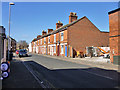
2
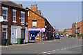
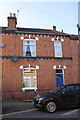
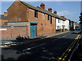
Wharncliffe Road, Loughborough
This area of the town includes a large number of tightly-packed terraced houses. A modern version of the corner shop stands on the corner of Moor Lane - the NIR Convenience Store.
Image: © Stephen McKay
Taken: 23 Mar 2022
0.06 miles
3
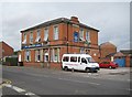
Loughborough: The Carpenter's Arms
Formerly the Corporation Hotel, the Carpenter's Arms has, since 2009, been a Christian run 12 room residential rehabilitation centre for men challenged by drug and alcohol addiction. Prior to this it was in use as a homeless hostel.
The building is locally listed and the Charnwood Borough Council website describes it thus:
"Hotel / Public House. Now used as a hostel. Late C19. Plain Italianate styling. Red brick. Stone string course between 1st & 2nd floor. Stone cornice under eaves. Stone dressings to openings. Slate hipped roof. Feature brick stacks rising through eaves on each return facade. 2 tall storeys. Square on plan with annexe at rear. Ground floor windows to public rooms subdivided by rectangular pilasters. Main entrance offset under Italianate balustrade surmounting stone arched head containing fanlight. Stone relief above arch. Generally 4 paned vertical sliding sash windows to 1st floor. Ground Floor windows concealed behind vertical "blinds" obscuring top light."
The main entrance under the balustrade has since been bricked up.
Image: © Nigel Cox
Taken: 17 Jul 2011
0.07 miles
4
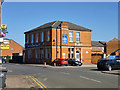
Formerly the Corporation Hotel, Loughborough
Now the Carpenter's Arms (illustrated only with his hands). Not a pub, but 'A Christian organization providing shelter and support'. A locally listed building, late 19th century.
Image: © Robin Webster
Taken: 25 Mar 2016
0.07 miles
5
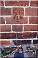
Benchmark on #12 Cobden Road
Ordnance Survey cut mark benchmark described on the Bench Mark Database at http://www.bench-marks.org.uk/bm70830
Image: © Roger Templeman
Taken: 30 Sep 2015
0.08 miles
6
#12 Cobden Road
There is an OS benchmark Image on the wall of the house about 1 foot right of the back of the left hand parked car, between two cables
Image: © Roger Templeman
Taken: 30 Sep 2015
0.08 miles
7
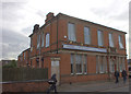
Christian rehabilitation centre, Loughborough
Formerly the Corporation Hotel.
Image: © Robert Eva
Taken: 7 Oct 2017
0.08 miles
8
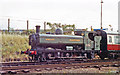
Preserved ex-GWR 0-6-0PT on Great Central Railway at Loughborough, 1992
Collett '5700' class 0-6-0PT no. 7760 is evidently in working order. It was built 12/30, transferred to the LTE in 12/61 as no. L90, withdrawn 1971, then preserved and run on various heritage railways to date, including the Great Central Railway.
Image: © Ben Brooksbank
Taken: 5 Sep 1992
0.11 miles
10
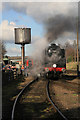
Playing to the Gallery, Great Central Railway
No. 70013 Oliver Cromwell getting its photograph taken by an adoring horde alongside the water crane at Loughborough.
Image: © Chris Allen
Taken: 28 Jan 2012
0.12 miles