IMAGES TAKEN NEAR TO
Cradock Street, LOUGHBOROUGH, LE11 1AH
Introduction
This page details the photographs taken nearby to Cradock Street, LE11 1AH by members of the Geograph project.
The Geograph project started in 2005 with the aim of publishing, organising and preserving representative images for every square kilometre of Great Britain, Ireland and the Isle of Man.

There are currently over 7.5m images from over14,400 individuals and you can help contribute to the project by visiting https://www.geograph.org.uk
Image Map (Loading...)


Getting Data...Please wait
Leaflet Map data © OpenStreetMap
Images are licensed for reuse under creativecommons.org/licenses/by-sa/2.0
Notes
- Clicking on the map will re-center to the selected point.
- The higher the marker number, the further away the image location is from the centre of the postcode.
Image Listing (425 Images Found)
Images are licensed for reuse under creativecommons.org/licenses/by-sa/2.0
Image
Details
Distance
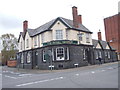
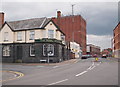
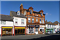
2
Formerly the Royal George, Loughborough
Now apparently the premises of Netbuster, dealing in carp and coarse fishing equipment. A locally listed building, late 19th century.
Image: © Robin Webster
Taken: 25 Mar 2016
0.04 miles
3
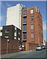
Loughborough telephone exchange
The Cradock Street side of the building.
Image: © Thomas Nugent
Taken: 8 Sep 2014
0.04 miles

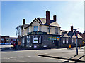
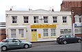
6
Loughborough, Leics (Coneries)
The 'locally listed' Royal George pub occupying the corner of Cradock Street and The Coneries. This is a late 19th century construction in what is described as in "severe Gothic/Domestic Revival style". The tall brick building on the left, in the direction of Baxtergate is currently occupied by British Telecom plc. The Coneries derives its name from the rabbit (or coney) warrens in the vicinity that provided fresh rabbit meat for consumption at Loughborough Manor House.
Image: © David Hallam-Jones
Taken: 7 Jul 2012
0.04 miles
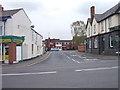
8
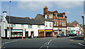
Nottingham Road
Cradock Street is on the right.
Image: © Thomas Nugent
Taken: 8 Sep 2014
0.05 miles
9
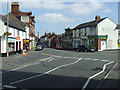
Nottingham Road
Nottingham Road is in the foreground and continuing to the left after the Give Way line. Cradock Street is on the right.
Image: © Thomas Nugent
Taken: 8 Sep 2014
0.05 miles
10
Former pub, Nottingham Road
The stonework above the main door bears the date 1887. Painted on the wall at the top is what looks like ' The Stag & Pheasant Home Ales'.
Image: © Robin Webster
Taken: 25 Mar 2016
0.05 miles